Aldealafuente geodata
Aldealafuente (Castille and León) is a seat of a third-order administrative division; located in Spain in Europe/Madrid (GMT+2) time zone. With population of 122 people, there are 5674 cities with bigger population in this country. Compared to other cities in Spain, 65.3% of cities are located further ↓South; 63.1% of cities are located further ←West and 88.6% of cities have lower elevation than Aldealafuente. Note1
Administrative division(s):
- Level 1: Castille and León
- Level 2: Provincia de Soria
- Level 3: Aldealafuente


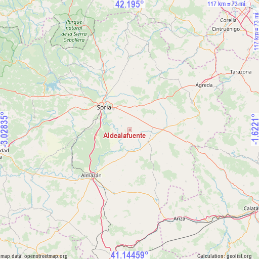
Aldealafuente GPS coordinates[2]
41° 40' 18.984" North, 2° 19' 30.792" West
| Map corner | latitude | longitude |
|---|---|---|
| Upper-left | 42.195°, | -3.02835° |
| Center: | 41.67194°, | -2.32522° |
| Lower-right: | 41.14459°, | -1.6221° |
| Map W x H: | 116.8×116.8 km | = 72.6×72.6mi |
| max Lat: | 43.74134° ⇑34.7% North |
| Aldealafuente: | 41.67194° |
| min Lat: | ⇓65.3% South 27.64134° |
| min Long | Aldealafuente | max Long |
| -18.00367° | -2.32522° | 4.2899° |
| W 63.1%⇐ | ⇒36.9% E |
Elevation
Elevation of Aldealafuente is 1008 m = 3307 ft, and this is 410 m = 1345 ft above average elevation for this country.
| Max E: |
1682 m = 5518 ft | 11.4% |
| Aldealafuente | 1008 m 3307 ft | |
| Avg. | 598 m = 1962 ft | |
Min E: |
0 m = 0 ft | 88.6% |
See also: Spain elevation on elevation.city.
Geographical zone
Aldealafuente is located in North temperate zone (between Tropic of Cancer and the Arctic Circle). Distance of this Northern Tropic circle is 2027.6 km =1259.9 mi to South.| Distance of | km | miles | from Aldealafuente |
|---|---|---|---|
| North Pole | 5373.6 | 3339 | to North |
| Arctic Circle | 2767.7 | 1719.8 | to North |
| Tropic Cancer | 2027.6 | 1259.9 | to South |
| Equator | 4633.5 | 2879.1 | to South |


Nearby cities:
15 places around Aldealafuente: (largest is in red/bold)
• Alconaba
7.6 km =4.7 mi,  319°
319°
• Aldealpozo
15.9 km =9.9 mi,  39°
39°
• Aliud
6.3 km =3.9 mi,  108°
108°
• Almenar de Soria
10.4 km =6.5 mi,  83°
83°
• Arancón
14.7 km =9.1 mi,  14°
14°
• Borjabad
13.7 km =8.5 mi,  194°
194°
• Buberos
11.2 km =7 mi,  104°
104°
• Cabrejas del Campo
4.7 km =2.9 mi, 77°
• Candilichera
4.1 km =2.5 mi,  28°
28°
• Cubo de la Solana
11.2 km =7 mi,  225°
225°
• Gómara
9.9 km =6.2 mi,  122°
122°
• Nolay
16.2 km =10.1 mi, 187°
• Soria
15.7 km =9.8 mi,  310°
310°
• Tejado
10.4 km =6.5 mi,  152°
152°
• Villaseca de Arciel
14.6 km =9.1 mi, 111°
Sources, notices
• [Note1] Compared only with cities in Spain existing in our database
• [Src1] Map data: © OpenStreetMap contributors (CC-BY-SA)
• [Src2] Other city data from geonames.org with taken over terms of usage.
• [Src3] Geographical zone / Annual Mean Temperature by Robert A. Rohde @ Wikipedia
