Chapinería geodata
Chapinería (Madrid) is a seat of a third-order administrative division; located in Spain in Europe/Madrid (GMT+2) time zone. With population of 1,832 people, there are 2268 cities with bigger population in this country. Compared to other cities in Spain, 64.4% of cities are located further ↑North; 62.8% of cities are located further →East and 52% of cities have lower elevation than Chapinería. Note1


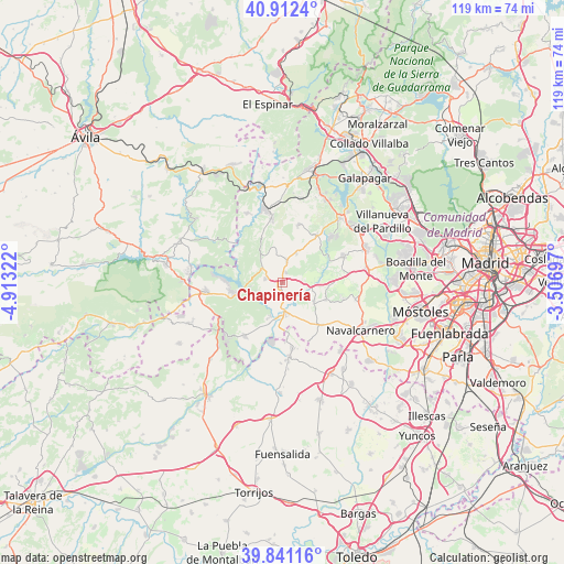
Chapinería GPS coordinates[2]
40° 22' 44.076" North, 4° 12' 36.324" West
| Map corner | latitude | longitude |
|---|---|---|
| Upper-left | 40.9124°, | -4.91322° |
| Center: | 40.37891°, | -4.21009° |
| Lower-right: | 39.84116°, | -3.50697° |
| Map W x H: | 119.1×119.1 km | = 74×74mi |
| max Lat: | 43.74134° ⇑64.4% North |
| Chapinería: | 40.37891° |
| min Lat: | ⇓35.6% South 27.64134° |
| min Long | Chapinería | max Long |
| -18.00367° | -4.21009° | 4.2899° |
| W 37.2%⇐ | ⇒62.8% E |
Elevation
Elevation of Chapinería is 680 m = 2231 ft, and this is 82 m = 269 ft above average elevation for this country.
| Max E: |
1682 m = 5518 ft | 48% |
| Chapinería | 680 m 2231 ft | |
| Avg. | 598 m = 1962 ft | |
Min E: |
0 m = 0 ft | 52% |
See also: Spain elevation on elevation.city.
Geographical zone
Chapinería is located in North temperate zone (between Tropic of Cancer and the Arctic Circle). Distance of this Northern Tropic circle is 1883.8 km =1170.5 mi to South.| Distance of | km | miles | from Chapinería |
|---|---|---|---|
| North Pole | 5517.3 | 3428.3 | to North |
| Arctic Circle | 2911.5 | 1809.1 | to North |
| Tropic Cancer | 1883.8 | 1170.5 | to South |
| Equator | 4489.7 | 2789.8 | to South |


Nearby cities:
15 places around Chapinería: (largest is in red/bold)
• Aldea del Fresno
6.2 km =3.9 mi,  174°
174°
• Colmenar del Arroyo
4.6 km =2.9 mi,  12°
12°
• Fresnedillas
12.5 km =7.8 mi,  15°
15°
• Méntrida
15.6 km =9.7 mi, 174°
• Navalagamella
12.4 km =7.7 mi,  36°
36°
• Navas del Rey
3.6 km =2.2 mi,  282°
282°
• Pelayos de la Presa
10.7 km =6.6 mi,  259°
259°
• Quijorna
14.1 km =8.8 mi,  67°
67°
• Robledo de Chavela
13.7 km =8.5 mi,  350°
350°
• San Martín de Valdeiglesias
16.1 km =10 mi, 263°
• Sevilla La Nueva
15.9 km =9.9 mi,  102°
102°
• Villa del Prado
13.8 km =8.6 mi,  215°
215°
• Villamanta
12.4 km =7.7 mi,  136°
136°
• Villamantilla
8.2 km =5.1 mi,  123°
123°
• Villanueva de Perales
10.1 km =6.3 mi,  111°
111°
Sources, notices
• [Note1] Compared only with cities in Spain existing in our database
• [Src1] Map data: © OpenStreetMap contributors (CC-BY-SA)
• [Src2] Other city data from geonames.org with taken over terms of usage.
• [Src3] Geographical zone / Annual Mean Temperature by Robert A. Rohde @ Wikipedia
