Serranillos del Valle geodata
Serranillos del Valle (Madrid) is a seat of a third-order administrative division; located in Spain in Europe/Madrid (GMT+2) time zone. With population of 2,710 people, there are 1813 cities with bigger population in this country. Compared to other cities in Spain, 67.2% of cities are located further ↑North; 58% of cities are located further →East and 50.3% of cities have lower elevation than Serranillos del Valle. Note1
Administrative division(s):
- Level 1: Madrid
- Level 2: Provincia de Madrid
- Level 3: Serranillos del Valle
Current local time in Serranillos del Valle:
10:43 PM, ThursdayDifference from your time zone: hours


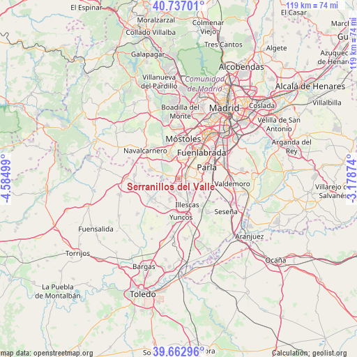
Serranillos del Valle GPS coordinates[2]
40° 12' 7.596" North, 3° 52' 54.732" West
| Map corner | latitude | longitude |
|---|---|---|
| Upper-left | 40.73701°, | -4.58499° |
| Center: | 40.20211°, | -3.88187° |
| Lower-right: | 39.66296°, | -3.17874° |
| Map W x H: | 119.4×119.4 km | = 74.2×74.2mi |
| max Lat: | 43.74134° ⇑67.2% North |
| Serranillos del Valle: | 40.20211° |
| min Lat: | ⇓32.8% South 27.64134° |
| min Long | Serranillos del | max Long |
| -18.00367° | -3.88187° | 4.2899° |
| W 42%⇐ | ⇒58% E |
Elevation
Elevation of Serranillos del Valle is 662 m = 2172 ft, and this is 64 m = 210 ft above average elevation for this country.
| Max E: |
1682 m = 5518 ft | 49.7% |
| Serranillos del Valle | 662 m 2172 ft | |
| Avg. | 598 m = 1962 ft | |
Min E: |
0 m = 0 ft | 50.3% |
See also: Spain elevation on elevation.city.
Geographical zone
Serranillos del Valle is located in North temperate zone (between Tropic of Cancer and the Arctic Circle). Distance of this Northern Tropic circle is 1864.1 km =1158.3 mi to South.| Distance of | km | miles | from Serranillos del Valle |
|---|---|---|---|
| North Pole | 5537 | 3440.5 | to North |
| Arctic Circle | 2931.1 | 1821.3 | to North |
| Tropic Cancer | 1864.1 | 1158.3 | to South |
| Equator | 4470.1 | 2777.6 | to South |


Nearby cities:
15 places around Serranillos del Valle: (largest is in red/bold)
• Arroyomolinos
8.1 km =5 mi,  336°
336°
• Batres
3.6 km =2.2 mi,  283°
283°
• Carranque
3.9 km =2.4 mi,  204°
204°
• Casarrubuelos
5.5 km =3.4 mi,  128°
128°
• Cubas
4.2 km =2.6 mi,  110°
110°
• El Viso de San Juan
7.4 km =4.6 mi, 204°
• El Álamo
10.1 km =6.3 mi,  288°
288°
• Griñón
2.6 km =1.6 mi,  63°
63°
• Humanes de Madrid
6.9 km =4.3 mi,  39°
39°
• Illescas
9.4 km =5.8 mi,  161°
161°
• Moraleja de Enmedio
6.8 km =4.2 mi,  16°
16°
• Parla
10.4 km =6.5 mi,  68°
68°
• Torrejón de Velasco
9.1 km =5.7 mi,  100°
100°
• Torrejón de la Calzada
7.2 km =4.5 mi,  92°
92°
• Ugena
5.2 km =3.2 mi,  174°
174°
Sources, notices
• [Note1] Compared only with cities in Spain existing in our database
• [Src1] Map data: © OpenStreetMap contributors (CC-BY-SA)
• [Src2] Other city data from geonames.org with taken over terms of usage.
• [Src3] Geographical zone / Annual Mean Temperature by Robert A. Rohde @ Wikipedia
