Humanes de Madrid geodata
Humanes de Madrid (Madrid) is a seat of a third-order administrative division; located in Spain in Europe/Madrid (GMT+2) time zone. With population of 18,098 people, there are 518 cities with bigger population in this country. Compared to other cities in Spain, 66.4% of cities are located further ↑North; 57.3% of cities are located further →East and 52% of cities have lower elevation than Humanes de Madrid. Note1


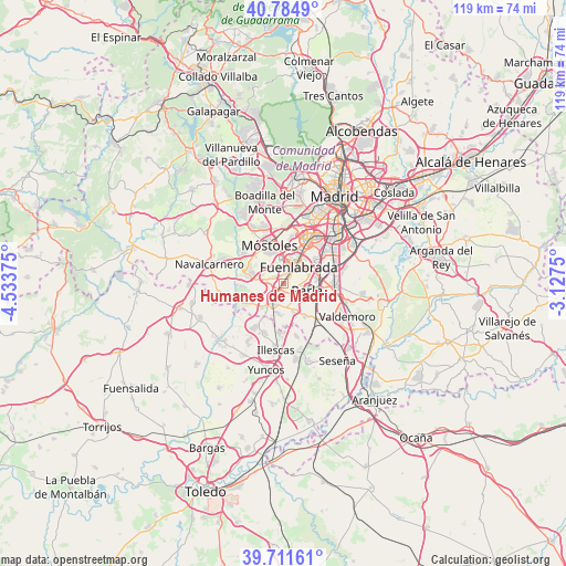
Humanes de Madrid GPS coordinates[2]
40° 15' 1.368" North, 3° 49' 50.232" West
| Map corner | latitude | longitude |
|---|---|---|
| Upper-left | 40.7849°, | -4.53375° |
| Center: | 40.25038°, | -3.83062° |
| Lower-right: | 39.71161°, | -3.1275° |
| Map W x H: | 119.3×119.3 km | = 74.1×74.1mi |
| max Lat: | 43.74134° ⇑66.4% North |
| Humanes de Madrid: | 40.25038° |
| min Lat: | ⇓33.6% South 27.64134° |
| min Long | Humanes de Madr | max Long |
| -18.00367° | -3.83062° | 4.2899° |
| W 42.7%⇐ | ⇒57.3% E |
Elevation
Elevation of Humanes de Madrid is 680 m = 2231 ft, and this is 82 m = 269 ft above average elevation for this country.
| Max E: |
1682 m = 5518 ft | 48% |
| Humanes de Madrid | 680 m 2231 ft | |
| Avg. | 598 m = 1962 ft | |
Min E: |
0 m = 0 ft | 52% |
See also: Spain elevation on elevation.city.
Geographical zone
Humanes de Madrid is located in North temperate zone (between Tropic of Cancer and the Arctic Circle). Distance of this Northern Tropic circle is 1869.5 km =1161.7 mi to South.| Distance of | km | miles | from Humanes de Madrid |
|---|---|---|---|
| North Pole | 5531.6 | 3437.2 | to North |
| Arctic Circle | 2925.8 | 1818 | to North |
| Tropic Cancer | 1869.5 | 1161.7 | to South |
| Equator | 4475.4 | 2780.9 | to South |


Nearby cities:
15 places around Humanes de Madrid: (largest is in red/bold)
• Alcorcón
10.6 km =6.6 mi,  2°
2°
• Arroyomolinos
7.8 km =4.8 mi,  285°
285°
• Batres
9.1 km =5.7 mi,  240°
240°
• Casarrubuelos
8.8 km =5.5 mi,  180°
180°
• Cubas
6.8 km =4.2 mi, 183°
• Fuenlabrada
4.9 km =3 mi,  39°
39°
• Getafe
10.3 km =6.4 mi,  53°
53°
• Griñón
4.7 km =2.9 mi,  205°
205°
• Leganés
10.3 km =6.4 mi,  33°
33°
• Moraleja de Enmedio
2.7 km =1.7 mi,  296°
296°
• Móstoles
8.5 km =5.3 mi,  339°
339°
• Parla
5.6 km =3.5 mi,  106°
106°
• Serranillos del Valle
6.9 km =4.3 mi,  219°
219°
• Torrejón de Velasco
8.4 km =5.2 mi,  146°
146°
• Torrejón de la Calzada
6.4 km =4 mi, 153°
Sources, notices
• [Note1] Compared only with cities in Spain existing in our database
• [Src1] Map data: © OpenStreetMap contributors (CC-BY-SA)
• [Src2] Other city data from geonames.org with taken over terms of usage.
• [Src3] Geographical zone / Annual Mean Temperature by Robert A. Rohde @ Wikipedia
