Parla geodata
Parla (Madrid) is a seat of a third-order administrative division; located in Spain in Europe/Madrid (GMT+2) time zone. With population of 115,611 people, there are 81 cities with bigger population in this country. Compared to other cities in Spain, 66.7% of cities are located further ↑North; 56.2% of cities are located further →East and 51% of cities have higher elevation than Parla. Note1


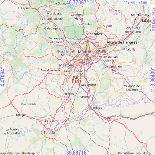
Parla GPS coordinates[2]
40° 14' 9.744" North, 3° 46' 3.072" West
| Map corner | latitude | longitude |
|---|---|---|
| Upper-left | 40.77067°, | -4.47064° |
| Center: | 40.23604°, | -3.76752° |
| Lower-right: | 39.69716°, | -3.06439° |
| Map W x H: | 119.4×119.4 km | = 74.2×74.2mi |
| max Lat: | 43.74134° ⇑66.7% North |
| Parla: | 40.23604° |
| min Lat: | ⇓33.3% South 27.64134° |
| min Long | Parla | max Long |
| -18.00367° | -3.76752° | 4.2899° |
| W 43.8%⇐ | ⇒56.2% E |
Elevation
Elevation of Parla is 648 m = 2126 ft, and this is 50 m = 164 ft above average elevation for this country.
| Max E: |
1682 m = 5518 ft | 51% |
| Parla | 648 m 2126 ft | |
| Avg. | 598 m = 1962 ft | |
Min E: |
0 m = 0 ft | 49% |
See also: Parla elevation on elevation.city.
Geographical zone
Parla is located in North temperate zone (between Tropic of Cancer and the Arctic Circle). Distance of this Northern Tropic circle is 1867.9 km =1160.7 mi to South.| Distance of | km | miles | from Parla |
|---|---|---|---|
| North Pole | 5533.2 | 3438.2 | to North |
| Arctic Circle | 2927.3 | 1818.9 | to North |
| Tropic Cancer | 1867.9 | 1160.7 | to South |
| Equator | 4473.8 | 2779.9 | to South |


Nearby cities:
15 places around Parla: (largest is in red/bold)
• Casarrubuelos
9 km =5.6 mi,  216°
216°
• Cubas
7.8 km =4.8 mi,  227°
227°
• Fuenlabrada
5.8 km =3.6 mi,  337°
337°
• Getafe
8.3 km =5.2 mi,  20°
20°
• Griñón
7.9 km =4.9 mi,  250°
250°
• Humanes de Madrid
5.6 km =3.5 mi,  286°
286°
• Leganés
10.1 km =6.3 mi,  1°
1°
• Moraleja de Enmedio
8.3 km =5.2 mi, 289°
• Móstoles
12.7 km =7.9 mi,  319°
319°
• Pinto
5.8 km =3.6 mi,  83°
83°
• Serranillos del Valle
10.4 km =6.5 mi, 248°
• Torrejón de Velasco
5.5 km =3.4 mi,  188°
188°
• Torrejón de la Calzada
4.8 km =3 mi,  211°
211°
• Ugena
12.8 km =8 mi, 225°
• Valdemoro
9.1 km =5.7 mi,  123°
123°
Sources, notices
• [Note1] Compared only with cities in Spain existing in our database
• [Src1] Map data: © OpenStreetMap contributors (CC-BY-SA)
• [Src2] Other city data from geonames.org with taken over terms of usage.
• [Src3] Geographical zone / Annual Mean Temperature by Robert A. Rohde @ Wikipedia
