Griñón geodata
Griñón (Madrid) is a seat of a third-order administrative division; located in Spain in Europe/Madrid (GMT+2) time zone. With population of 7,484 people, there are 980 cities with bigger population in this country. Compared to other cities in Spain, 67% of cities are located further ↑North; 57.6% of cities are located further →East and 51.6% of cities have lower elevation than Griñón. Note1


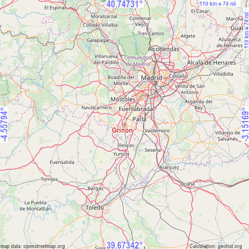
Griñón GPS coordinates[2]
40° 12' 44.964" North, 3° 51' 17.352" West
| Map corner | latitude | longitude |
|---|---|---|
| Upper-left | 40.74731°, | -4.55794° |
| Center: | 40.21249°, | -3.85482° |
| Lower-right: | 39.67342°, | -3.15169° |
| Map W x H: | 119.4×119.4 km | = 74.2×74.2mi |
| max Lat: | 43.74134° ⇑67% North |
| Griñón: | 40.21249° |
| min Lat: | ⇓33% South 27.64134° |
| min Long | Griñón | max Long |
| -18.00367° | -3.85482° | 4.2899° |
| W 42.4%⇐ | ⇒57.6% E |
Elevation
Elevation of Griñón is 676 m = 2218 ft, and this is 78 m = 256 ft above average elevation for this country.
| Max E: |
1682 m = 5518 ft | 48.4% |
| Griñón | 676 m 2218 ft | |
| Avg. | 598 m = 1962 ft | |
Min E: |
0 m = 0 ft | 51.6% |
See also: Spain elevation on elevation.city.
Geographical zone
Griñón is located in North temperate zone (between Tropic of Cancer and the Arctic Circle). Distance of this Northern Tropic circle is 1865.3 km =1159 mi to South.| Distance of | km | miles | from Griñón |
|---|---|---|---|
| North Pole | 5535.9 | 3439.8 | to North |
| Arctic Circle | 2930 | 1820.6 | to North |
| Tropic Cancer | 1865.3 | 1159 | to South |
| Equator | 4471.2 | 2778.3 | to South |


Nearby cities:
15 places around Griñón: (largest is in red/bold)
• Arroyomolinos
8.4 km =5.2 mi,  319°
319°
• Batres
5.8 km =3.6 mi,  267°
267°
• Carranque
6.2 km =3.9 mi,  219°
219°
• Casarrubuelos
5 km =3.1 mi,  156°
156°
• Cubas
3.1 km =1.9 mi,  147°
147°
• El Viso de San Juan
9.5 km =5.9 mi,  214°
214°
• Fuenlabrada
9.5 km =5.9 mi,  32°
32°
• Humanes de Madrid
4.7 km =2.9 mi, 25°
• Illescas
10.1 km =6.3 mi,  176°
176°
• Moraleja de Enmedio
5.4 km =3.4 mi,  355°
355°
• Parla
7.9 km =4.9 mi,  70°
70°
• Serranillos del Valle
2.6 km =1.6 mi,  243°
243°
• Torrejón de Velasco
7.2 km =4.5 mi,  112°
112°
• Torrejón de la Calzada
5.1 km =3.2 mi, 107°
• Ugena
6.6 km =4.1 mi,  195°
195°
Sources, notices
• [Note1] Compared only with cities in Spain existing in our database
• [Src1] Map data: © OpenStreetMap contributors (CC-BY-SA)
• [Src2] Other city data from geonames.org with taken over terms of usage.
• [Src3] Geographical zone / Annual Mean Temperature by Robert A. Rohde @ Wikipedia
