Mijares geodata
Mijares (Castille and León) is a seat of a third-order administrative division; located in Spain in Europe/Madrid (GMT+2) time zone. With population of 906 people, there are 3062 cities with bigger population in this country. Compared to other cities in Spain, 65.9% of cities are located further ↑North; 70.2% of cities are located further →East and 75% of cities have lower elevation than Mijares. Note1


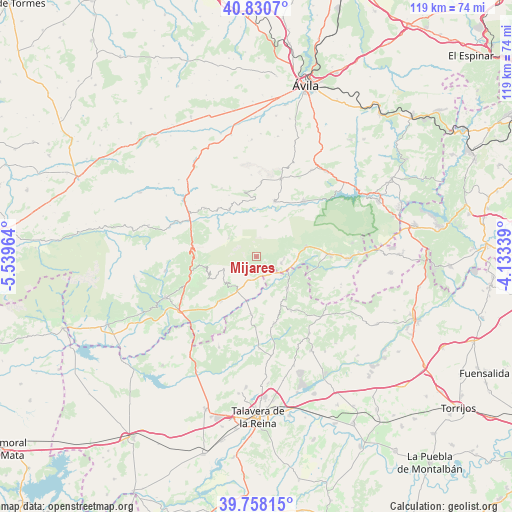
Mijares GPS coordinates[2]
40° 17' 47.58" North, 4° 50' 11.436" West
| Map corner | latitude | longitude |
|---|---|---|
| Upper-left | 40.8307°, | -5.53964° |
| Center: | 40.29655°, | -4.83651° |
| Lower-right: | 39.75815°, | -4.13339° |
| Map W x H: | 119.3×119.3 km | = 74.1×74.1mi |
| max Lat: | 43.74134° ⇑65.9% North |
| Mijares: | 40.29655° |
| min Lat: | ⇓34.1% South 27.64134° |
| min Long | Mijares | max Long |
| -18.00367° | -4.83651° | 4.2899° |
| W 29.8%⇐ | ⇒70.2% E |
Elevation
Elevation of Mijares is 851 m = 2792 ft, and this is 253 m = 830 ft above average elevation for this country.
| Max E: |
1682 m = 5518 ft | 25% |
| Mijares | 851 m 2792 ft | |
| Avg. | 598 m = 1962 ft | |
Min E: |
0 m = 0 ft | 75% |
See also: Spain elevation on elevation.city.
Geographical zone
Mijares is located in North temperate zone (between Tropic of Cancer and the Arctic Circle). Distance of this Northern Tropic circle is 1874.6 km =1164.8 mi to South.| Distance of | km | miles | from Mijares |
|---|---|---|---|
| North Pole | 5526.5 | 3434 | to North |
| Arctic Circle | 2920.6 | 1814.8 | to North |
| Tropic Cancer | 1874.6 | 1164.8 | to South |
| Equator | 4480.6 | 2784.1 | to South |


Nearby cities:
15 places around Mijares: (largest is in red/bold)
• Buenaventura
13.3 km =8.3 mi,  184°
184°
• Burgohondo
13.8 km =8.6 mi,  18°
18°
• Casavieja
6.1 km =3.8 mi,  104°
104°
• Cuevas del Valle
14.7 km =9.1 mi,  268°
268°
• Gavilanes
2.5 km =1.6 mi,  214°
214°
• Lanzahita
13.2 km =8.2 mi,  219°
219°
• Navalosa
14.2 km =8.8 mi,  325°
325°
• Navarrevisca
8.9 km =5.5 mi, 327°
• Navatalgordo
13.5 km =8.4 mi,  347°
347°
• Pedro Bernardo
8.7 km =5.4 mi,  225°
225°
• Piedralaves
11.8 km =7.3 mi,  78°
78°
• San Esteban del Valle
12.6 km =7.8 mi,  259°
259°
• Sartajada
9.9 km =6.2 mi,  158°
158°
• Serranillos
7.8 km =4.8 mi,  304°
304°
• Villarejo del Valle
13.6 km =8.5 mi, 265°
Sources, notices
• [Note1] Compared only with cities in Spain existing in our database
• [Src1] Map data: © OpenStreetMap contributors (CC-BY-SA)
• [Src2] Other city data from geonames.org with taken over terms of usage.
• [Src3] Geographical zone / Annual Mean Temperature by Robert A. Rohde @ Wikipedia
