Gavilanes geodata
Gavilanes (Castille and León) is a seat of a third-order administrative division; located in Spain in Europe/Madrid (GMT+2) time zone. With population of 686 people, there are 3423 cities with bigger population in this country. Compared to other cities in Spain, 66.1% of cities are located further ↑North; 70.5% of cities are located further →East and 52.5% of cities have lower elevation than Gavilanes. Note1
Administrative division(s):
- Level 1: Castille and León
- Level 2: Provincia de Ávila
- Level 3: Gavilanes


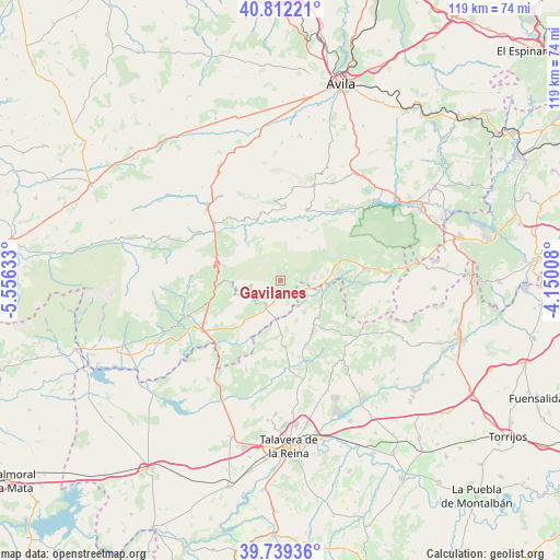
Gavilanes GPS coordinates[2]
40° 16' 40.476" North, 4° 51' 11.556" West
| Map corner | latitude | longitude |
|---|---|---|
| Upper-left | 40.81221°, | -5.55633° |
| Center: | 40.27791°, | -4.85321° |
| Lower-right: | 39.73936°, | -4.15008° |
| Map W x H: | 119.3×119.3 km | = 74.1×74.1mi |
| max Lat: | 43.74134° ⇑66.1% North |
| Gavilanes: | 40.27791° |
| min Lat: | ⇓33.9% South 27.64134° |
| min Long | Gavilanes | max Long |
| -18.00367° | -4.85321° | 4.2899° |
| W 29.5%⇐ | ⇒70.5% E |
Elevation
Elevation of Gavilanes is 685 m = 2247 ft, and this is 87 m = 285 ft above average elevation for this country.
| Max E: |
1682 m = 5518 ft | 47.5% |
| Gavilanes | 685 m 2247 ft | |
| Avg. | 598 m = 1962 ft | |
Min E: |
0 m = 0 ft | 52.5% |
See also: Spain elevation on elevation.city.
Geographical zone
Gavilanes is located in North temperate zone (between Tropic of Cancer and the Arctic Circle). Distance of this Northern Tropic circle is 1872.6 km =1163.6 mi to South.| Distance of | km | miles | from Gavilanes |
|---|---|---|---|
| North Pole | 5528.6 | 3435.3 | to North |
| Arctic Circle | 2922.7 | 1816.1 | to North |
| Tropic Cancer | 1872.6 | 1163.6 | to South |
| Equator | 4478.5 | 2782.8 | to South |


Nearby cities:
15 places around Gavilanes: (largest is in red/bold)
• Almendral de la Cañada
14 km =8.7 mi,  137°
137°
• Buenaventura
11.2 km =7 mi,  178°
178°
• Casavieja
7.4 km =4.6 mi,  85°
85°
• Cuevas del Valle
13.4 km =8.3 mi,  277°
277°
• Lanzahita
10.7 km =6.6 mi,  220°
220°
• Mijares
2.5 km =1.6 mi,  34°
34°
• Mombeltrán
14.1 km =8.8 mi,  261°
261°
• Navarrevisca
10.2 km =6.3 mi,  340°
340°
• Pedro Bernardo
6.2 km =3.9 mi,  230°
230°
• Piedralaves
13.7 km =8.5 mi,  71°
71°
• San Esteban del Valle
10.9 km =6.8 mi,  268°
268°
• Santa Cruz del Valle
12.9 km =8 mi, 256°
• Sartajada
8.8 km =5.5 mi,  145°
145°
• Serranillos
8.2 km =5.1 mi,  322°
322°
• Villarejo del Valle
12.2 km =7.6 mi, 274°
Sources, notices
• [Note1] Compared only with cities in Spain existing in our database
• [Src1] Map data: © OpenStreetMap contributors (CC-BY-SA)
• [Src2] Other city data from geonames.org with taken over terms of usage.
• [Src3] Geographical zone / Annual Mean Temperature by Robert A. Rohde @ Wikipedia
