Seno geodata
Seno (Aragon) is a seat of a third-order administrative division; located in Spain in Europe/Madrid (GMT+2) time zone. With population of 46 people, there are 6506 cities with bigger population in this country. Compared to other cities in Spain, 55.9% of cities are located further ↑North; 84.1% of cities are located further ←West and 69.5% of cities have lower elevation than Seno. Note1


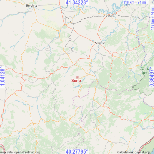
Seno GPS coordinates[2]
40° 48' 44.1" North, 0° 20' 17.376" West
| Map corner | latitude | longitude |
|---|---|---|
| Upper-left | 41.34228°, | -1.04128° |
| Center: | 40.81225°, | -0.33816° |
| Lower-right: | 40.27795°, | 0.36497° |
| Map W x H: | 118.3×118.3 km | = 73.5×73.5mi |
| max Lat: | 43.74134° ⇑55.9% North |
| Seno: | 40.81225° |
| min Lat: | ⇓44.1% South 27.64134° |
| min Long | Seno | max Long |
| -18.00367° | -0.33816° | 4.2899° |
| W 84.1%⇐ | ⇒15.9% E |
Elevation
Elevation of Seno is 811 m = 2661 ft, and this is 213 m = 699 ft above average elevation for this country.
| Max E: |
1682 m = 5518 ft | 30.5% |
| Seno | 811 m 2661 ft | |
| Avg. | 598 m = 1962 ft | |
Min E: |
0 m = 0 ft | 69.5% |
See also: Spain elevation on elevation.city.
Geographical zone
Seno is located in North temperate zone (between Tropic of Cancer and the Arctic Circle). Distance of this Northern Tropic circle is 1932 km =1200.5 mi to South.| Distance of | km | miles | from Seno |
|---|---|---|---|
| North Pole | 5469.2 | 3398.4 | to North |
| Arctic Circle | 2863.3 | 1779.2 | to North |
| Tropic Cancer | 1932 | 1200.5 | to South |
| Equator | 4537.9 | 2819.7 | to South |


Nearby cities:
15 places around Seno: (largest is in red/bold)
• Aguaviva
12.1 km =7.5 mi,  84°
84°
• Alcorisa
9.6 km =6 mi,  337°
337°
• Berge
9 km =5.6 mi,  304°
304°
• Bordón
14 km =8.7 mi,  174°
174°
• Calanda
16.9 km =10.5 mi,  31°
31°
• Castellote
2.1 km =1.3 mi,  131°
131°
• Ejulve
18.6 km =11.6 mi,  257°
257°
• Foz-Calanda
13.7 km =8.5 mi, 26°
• La Ginebrosa
18.2 km =11.3 mi,  69°
69°
• Mas de las Matas
8.4 km =5.2 mi, 73°
• Molinos
9.5 km =5.9 mi,  275°
275°
• Olocau del Rey
19.4 km =12.1 mi,  180°
180°
• Palanques
17 km =10.6 mi, 128°
• Villores
19.2 km =11.9 mi,  142°
142°
• Zorita del Maestrazgo
17.2 km =10.7 mi,  122°
122°
Sources, notices
• [Note1] Compared only with cities in Spain existing in our database
• [Src1] Map data: © OpenStreetMap contributors (CC-BY-SA)
• [Src2] Other city data from geonames.org with taken over terms of usage.
• [Src3] Geographical zone / Annual Mean Temperature by Robert A. Rohde @ Wikipedia
