La Ginebrosa geodata
La Ginebrosa (Aragon) is a seat of a third-order administrative division; located in Spain in Europe/Madrid (GMT+2) time zone. With population of 236 people, there are 4828 cities with bigger population in this country. Compared to other cities in Spain, 54.5% of cities are located further ↑North; 86.1% of cities are located further ←West and 55.9% of cities have lower elevation than La Ginebrosa. Note1


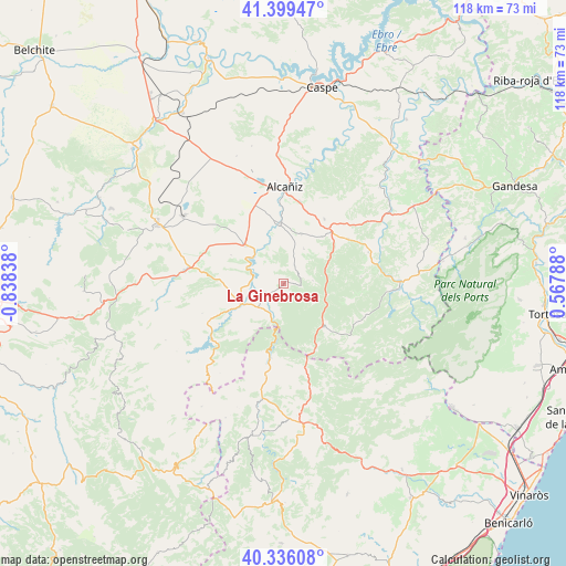
La Ginebrosa GPS coordinates[2]
40° 52' 11.676" North, 0° 8' 6.9" West
| Map corner | latitude | longitude |
|---|---|---|
| Upper-left | 41.39947°, | -0.83838° |
| Center: | 40.86991°, | -0.13525° |
| Lower-right: | 40.33608°, | 0.56788° |
| Map W x H: | 118.2×118.2 km | = 73.4×73.4mi |
| max Lat: | 43.74134° ⇑54.5% North |
| La Ginebrosa: | 40.86991° |
| min Lat: | ⇓45.5% South 27.64134° |
| min Long | La Ginebrosa | max Long |
| -18.00367° | -0.13525° | 4.2899° |
| W 86.1%⇐ | ⇒13.9% E |
Elevation
Elevation of La Ginebrosa is 715 m = 2346 ft, and this is 117 m = 384 ft above average elevation for this country.
| Max E: |
1682 m = 5518 ft | 44.1% |
| La Ginebrosa | 715 m 2346 ft | |
| Avg. | 598 m = 1962 ft | |
Min E: |
0 m = 0 ft | 55.9% |
See also: Spain elevation on elevation.city.
Geographical zone
La Ginebrosa is located in North temperate zone (between Tropic of Cancer and the Arctic Circle). Distance of this Northern Tropic circle is 1938.4 km =1204.5 mi to South.| Distance of | km | miles | from La Ginebrosa |
|---|---|---|---|
| North Pole | 5462.8 | 3394.4 | to North |
| Arctic Circle | 2856.9 | 1775.2 | to North |
| Tropic Cancer | 1938.4 | 1204.5 | to South |
| Equator | 4544.3 | 2823.7 | to South |


Nearby cities:
15 places around La Ginebrosa: (largest is in red/bold)
• Aguaviva
7.3 km =4.5 mi,  223°
223°
• Calanda
11.4 km =7.1 mi,  314°
314°
• Castelserás
12.4 km =7.7 mi,  355°
355°
• Foz-Calanda
12.3 km =7.6 mi,  298°
298°
• Fórnoles
11.4 km =7.1 mi,  76°
76°
• Mas de las Matas
9.9 km =6.2 mi,  246°
246°
• Monroyo
12.4 km =7.7 mi,  137°
137°
• Palanques
17.3 km =10.7 mi,  192°
192°
• Ráfales
13.5 km =8.4 mi,  105°
105°
• Torre de Arcas
14.3 km =8.9 mi,  157°
157°
• Torrecilla de Alcañiz
10.7 km =6.6 mi,  20°
20°
• Torrevelilla
4.2 km =2.6 mi,  30°
30°
• Valdealgorfa
15.9 km =9.9 mi, 32°
• Valjunquera
16.4 km =10.2 mi,  55°
55°
• Zorita del Maestrazgo
16 km =9.9 mi, 189°
Sources, notices
• [Note1] Compared only with cities in Spain existing in our database
• [Src1] Map data: © OpenStreetMap contributors (CC-BY-SA)
• [Src2] Other city data from geonames.org with taken over terms of usage.
• [Src3] Geographical zone / Annual Mean Temperature by Robert A. Rohde @ Wikipedia
