Maqueda geodata
Maqueda (Castille-La Mancha) is a seat of a third-order administrative division; located in Spain in Europe/Madrid (GMT+2) time zone. With population of 513 people, there are 3843 cities with bigger population in this country. Compared to other cities in Spain, 69.2% of cities are located further ↑North; 64.6% of cities are located further →East and 63.2% of cities have higher elevation than Maqueda. Note1
Administrative division(s):
- Level 1: Castille-La Mancha
- Level 2: Province of Toledo
- Level 3: Maqueda


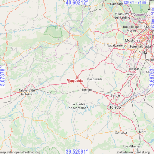
Maqueda GPS coordinates[2]
40° 3' 58.104" North, 4° 22' 14.376" West
| Map corner | latitude | longitude |
|---|---|---|
| Upper-left | 40.60212°, | -5.07378° |
| Center: | 40.06614°, | -4.37066° |
| Lower-right: | 39.52591°, | -3.66753° |
| Map W x H: | 119.7×119.7 km | = 74.4×74.4mi |
| max Lat: | 43.74134° ⇑69.2% North |
| Maqueda: | 40.06614° |
| min Lat: | ⇓30.8% South 27.64134° |
| min Long | Maqueda | max Long |
| -18.00367° | -4.37066° | 4.2899° |
| W 35.4%⇐ | ⇒64.6% E |
Elevation
Elevation of Maqueda is 484 m = 1588 ft, and this is 114 m = 374 ft below average elevation for this country.
| Max E: |
1682 m = 5518 ft | 63.2% |
| Avg. | 598 m = 1962 ft | |
| Maqueda | 484 m = 1588 ft | |
Min E: |
0 m = 0 ft | 36.8% |
See also: Spain elevation on elevation.city.
Geographical zone
Maqueda is located in North temperate zone (between Tropic of Cancer and the Arctic Circle). Distance of this Northern Tropic circle is 1849 km =1148.9 mi to South.| Distance of | km | miles | from Maqueda |
|---|---|---|---|
| North Pole | 5552.1 | 3449.9 | to North |
| Arctic Circle | 2946.2 | 1830.7 | to North |
| Tropic Cancer | 1849 | 1148.9 | to South |
| Equator | 4454.9 | 2768.1 | to South |


Nearby cities:
15 places around Maqueda: (largest is in red/bold)
• Alcabón
7.1 km =4.4 mi,  178°
178°
• Carmena
12.6 km =7.8 mi,  192°
192°
• Carriches
13.6 km =8.5 mi,  213°
213°
• El Casar de Escalona
13.3 km =8.3 mi,  260°
260°
• Escalona
11.6 km =7.2 mi,  345°
345°
• Fuensalida
14 km =8.7 mi,  96°
96°
• Gerindote
12.6 km =7.8 mi,  152°
152°
• Hormigos
7.2 km =4.5 mi,  299°
299°
• Novés
8.4 km =5.2 mi, 104°
• Otero
14.3 km =8.9 mi,  239°
239°
• Portillo de Toledo
12.1 km =7.5 mi,  91°
91°
• Quismondo
5.9 km =3.7 mi,  42°
42°
• Santa Cruz del Retamar
12.5 km =7.8 mi,  61°
61°
• Santa Olalla
6.9 km =4.3 mi,  226°
226°
• Torrijos
11.9 km =7.4 mi,  141°
141°
Sources, notices
• [Note1] Compared only with cities in Spain existing in our database
• [Src1] Map data: © OpenStreetMap contributors (CC-BY-SA)
• [Src2] Other city data from geonames.org with taken over terms of usage.
• [Src3] Geographical zone / Annual Mean Temperature by Robert A. Rohde @ Wikipedia
