Camargo geodata
Camargo (Cantabria) is a populated place; located in Spain in Europe/Madrid (GMT+2) time zone. With population of 31,404 people, there are 286 cities with bigger population in this country. Compared to other cities in Spain, 98.9% of cities are located further ↓South; 58.1% of cities are located further →East and 93.9% of cities have higher elevation than Camargo. Note1


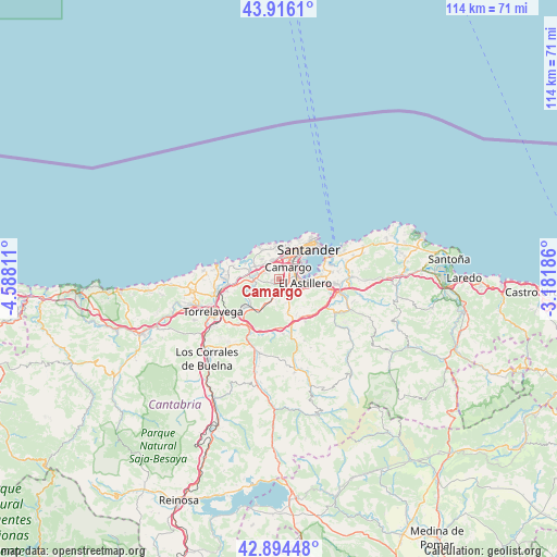
Camargo GPS coordinates[2]
43° 24' 26.784" North, 3° 53' 5.928" West
| Map corner | latitude | longitude |
|---|---|---|
| Upper-left | 43.9161°, | -4.58811° |
| Center: | 43.40744°, | -3.88498° |
| Lower-right: | 42.89448°, | -3.18186° |
| Map W x H: | 113.6×113.6 km | = 70.6×70.6mi |
| max Lat: | 43.74134° ⇑1.1% North |
| Camargo: | 43.40744° |
| min Lat: | ⇓98.9% South 27.64134° |
| min Long | Camargo | max Long |
| -18.00367° | -3.88498° | 4.2899° |
| W 41.9%⇐ | ⇒58.1% E |
Elevation
Elevation of Camargo is 32 m = 105 ft, and this is 566 m = 1857 ft below average elevation for this country.
| Max E: |
1682 m = 5518 ft | 93.9% |
| Avg. | 598 m = 1962 ft | |
| Camargo | 32 m = 105 ft | |
Min E: |
0 m = 0 ft | 6.1% |
See also: Spain elevation on elevation.city.
Geographical zone
Camargo is located in North temperate zone (between Tropic of Cancer and the Arctic Circle). Distance of this Northern Tropic circle is 2220.5 km =1379.8 mi to South.| Distance of | km | miles | from Camargo |
|---|---|---|---|
| North Pole | 5180.6 | 3219.1 | to North |
| Arctic Circle | 2574.7 | 1599.8 | to North |
| Tropic Cancer | 2220.5 | 1379.8 | to South |
| Equator | 4826.5 | 2999 | to South |


Nearby cities:
15 places around Camargo: (largest is in red/bold)
• El Astillero
5.3 km =3.3 mi,  97°
97°
• Entrambasaguas
16.8 km =10.4 mi, 101°
• Liérganes
13.1 km =8.1 mi,  121°
121°
• Miengo
9.5 km =5.9 mi,  284°
284°
• Penagos
8.4 km =5.2 mi,  136°
136°
• Polanco
10.9 km =6.8 mi,  256°
256°
• Puente Viesgo
13.9 km =8.6 mi,  208°
208°
• Santa Cruz de Bezana
4.3 km =2.7 mi,  339°
339°
• Santa María de Cayón
11.7 km =7.3 mi,  160°
160°
• Santander
9.1 km =5.7 mi,  45°
45°
• Saro
16.8 km =10.4 mi,  168°
168°
• Suances
13.1 km =8.1 mi, 282°
• Torrelavega
14.7 km =9.1 mi,  243°
243°
• Villafufre
15.8 km =9.8 mi,  182°
182°
• Villanueva de Villaescusa
4.8 km =3 mi, 158°
Sources, notices
• [Note1] Compared only with cities in Spain existing in our database
• [Src1] Map data: © OpenStreetMap contributors (CC-BY-SA)
• [Src2] Other city data from geonames.org with taken over terms of usage.
• [Src3] Geographical zone / Annual Mean Temperature by Robert A. Rohde @ Wikipedia
