Polanco geodata
Polanco (Cantabria) is a seat of a third-order administrative division; located in Spain in Europe/Madrid (GMT+2) time zone. With population of 1,000 people, there are 2939 cities with bigger population in this country. Compared to other cities in Spain, 98.7% of cities are located further ↓South; 59.9% of cities are located further →East and 90.9% of cities have higher elevation than Polanco. Note1


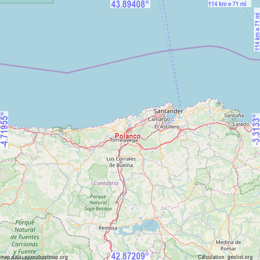
Polanco GPS coordinates[2]
43° 23' 6.864" North, 4° 0' 59.112" West
| Map corner | latitude | longitude |
|---|---|---|
| Upper-left | 43.89408°, | -4.71955° |
| Center: | 43.38524°, | -4.01642° |
| Lower-right: | 42.87209°, | -3.3133° |
| Map W x H: | 113.6×113.6 km | = 70.6×70.6mi |
| max Lat: | 43.74134° ⇑1.3% North |
| Polanco: | 43.38524° |
| min Lat: | ⇓98.7% South 27.64134° |
| min Long | Polanco | max Long |
| -18.00367° | -4.01642° | 4.2899° |
| W 40.1%⇐ | ⇒59.9% E |
Elevation
Elevation of Polanco is 53 m = 174 ft, and this is 545 m = 1788 ft below average elevation for this country.
| Max E: |
1682 m = 5518 ft | 90.9% |
| Avg. | 598 m = 1962 ft | |
| Polanco | 53 m = 174 ft | |
Min E: |
0 m = 0 ft | 9.1% |
See also: Spain elevation on elevation.city.
Geographical zone
Polanco is located in North temperate zone (between Tropic of Cancer and the Arctic Circle). Distance of this Northern Tropic circle is 2218.1 km =1378.3 mi to South.| Distance of | km | miles | from Polanco |
|---|---|---|---|
| North Pole | 5183.1 | 3220.6 | to North |
| Arctic Circle | 2577.2 | 1601.4 | to North |
| Tropic Cancer | 2218.1 | 1378.3 | to South |
| Equator | 4824 | 2997.5 | to South |


Nearby cities:
15 places around Polanco: (largest is in red/bold)
• Camargo
10.9 km =6.8 mi,  76°
76°
• Cartes
7.8 km =4.8 mi,  212°
212°
• El Astillero
15.9 km =9.9 mi, 83°
• Los Corrales de Buelna
14.3 km =8.9 mi,  198°
198°
• Miengo
5 km =3.1 mi,  16°
16°
• Penagos
16.8 km =10.4 mi,  102°
102°
• Puente Viesgo
10.4 km =6.5 mi,  158°
158°
• Reocín
8.1 km =5 mi,  230°
230°
• Santa Cruz de Bezana
11.2 km =7 mi,  54°
54°
• Santa María de Cayón
16.8 km =10.4 mi,  120°
120°
• Santillana
7.4 km =4.6 mi,  273°
273°
• Suances
5.8 km =3.6 mi,  337°
337°
• Torrelavega
4.7 km =2.9 mi, 212°
• Villafufre
16.6 km =10.3 mi,  143°
143°
• Villanueva de Villaescusa
12.6 km =7.8 mi, 99°
Sources, notices
• [Note1] Compared only with cities in Spain existing in our database
• [Src1] Map data: © OpenStreetMap contributors (CC-BY-SA)
• [Src2] Other city data from geonames.org with taken over terms of usage.
• [Src3] Geographical zone / Annual Mean Temperature by Robert A. Rohde @ Wikipedia
