Santa Cruz de Bezana geodata
Santa Cruz de Bezana (Cantabria) is a seat of a third-order administrative division; located in Spain in Europe/Madrid (GMT+2) time zone. With population of 11,279 people, there are 779 cities with bigger population in this country. Compared to other cities in Spain, 99.2% of cities are located further ↓South; 58.3% of cities are located further →East and 92.1% of cities have higher elevation than Santa Cruz de Bezana. Note1
Administrative division(s):
- Level 1: Cantabria
- Level 2: Provincia de Cantabria
- Level 3: Santa Cruz de Bezana


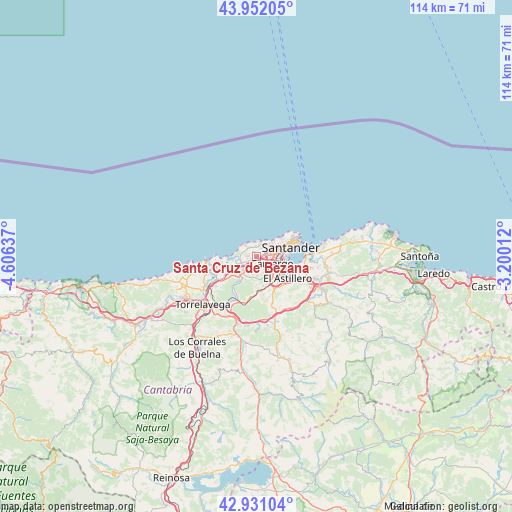
Santa Cruz de Bezana GPS coordinates[2]
43° 26' 37.32" North, 3° 54' 11.664" West
| Map corner | latitude | longitude |
|---|---|---|
| Upper-left | 43.95205°, | -4.60637° |
| Center: | 43.4437°, | -3.90324° |
| Lower-right: | 42.93104°, | -3.20012° |
| Map W x H: | 113.5×113.5 km | = 70.5×70.5mi |
| max Lat: | 43.74134° ⇑0.8% North |
| Santa Cruz de Bezana: | 43.4437° |
| min Lat: | ⇓99.2% South 27.64134° |
| min Long | Santa Cruz de B | max Long |
| -18.00367° | -3.90324° | 4.2899° |
| W 41.7%⇐ | ⇒58.3% E |
Elevation
Elevation of Santa Cruz de Bezana is 44 m = 144 ft, and this is 554 m = 1818 ft below average elevation for this country.
| Max E: |
1682 m = 5518 ft | 92.1% |
| Avg. | 598 m = 1962 ft | |
| Santa Cruz de Bezana | 44 m = 144 ft | |
Min E: |
0 m = 0 ft | 7.9% |
See also: Spain elevation on elevation.city.
Geographical zone
Santa Cruz de Bezana is located in North temperate zone (between Tropic of Cancer and the Arctic Circle). Distance of this Northern Tropic circle is 2224.6 km =1382.3 mi to South.| Distance of | km | miles | from Santa Cruz de Bezana |
|---|---|---|---|
| North Pole | 5176.6 | 3216.6 | to North |
| Arctic Circle | 2570.7 | 1597.4 | to North |
| Tropic Cancer | 2224.6 | 1382.3 | to South |
| Equator | 4830.5 | 3001.5 | to South |


Nearby cities:
15 places around Santa Cruz de Bezana: (largest is in red/bold)
• Camargo
4.3 km =2.7 mi,  159°
159°
• Cartes
18.7 km =11.6 mi,  225°
225°
• El Astillero
8.2 km =5.1 mi,  125°
125°
• Liérganes
16.7 km =10.4 mi, 130°
• Miengo
7.9 km =4.9 mi,  257°
257°
• Penagos
12.5 km =7.8 mi,  144°
144°
• Polanco
11.2 km =7 mi, 234°
• Puente Viesgo
17 km =10.6 mi,  197°
197°
• Reocín
19.3 km =12 mi, 232°
• Santa María de Cayón
16 km =9.9 mi, 160°
• Santander
8.3 km =5.2 mi,  73°
73°
• Santillana
17.7 km =11 mi,  249°
249°
• Suances
11.4 km =7.1 mi, 264°
• Torrelavega
15.7 km =9.8 mi, 228°
• Villanueva de Villaescusa
9.1 km =5.7 mi, 158°
Sources, notices
• [Note1] Compared only with cities in Spain existing in our database
• [Src1] Map data: © OpenStreetMap contributors (CC-BY-SA)
• [Src2] Other city data from geonames.org with taken over terms of usage.
• [Src3] Geographical zone / Annual Mean Temperature by Robert A. Rohde @ Wikipedia
