Santa Uxía de Ribeira geodata
Santa Uxía de Ribeira (Galicia) is a populated place; located in Spain in Europe/Madrid (GMT+2) time zone. With population of 27,159 people, there are 342 cities with bigger population in this country. Compared to other cities in Spain, 88.3% of cities are located further ↓South; 98.2% of cities are located further →East and 96.4% of cities have higher elevation than Santa Uxía de Ribeira. Note1
Current local time in Santa Uxía de Ribeira:
09:17 PM, ThursdayDifference from your time zone: hours


Santa Uxía de Ribeira GPS coordinates[2]
42° 33' 12.672" North, 8° 59' 27.384" West
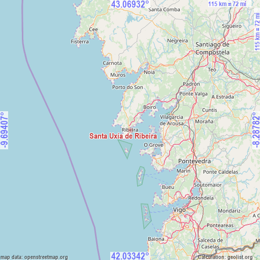
| Map corner | latitude | longitude |
|---|---|---|
| Upper-left | 43.06932°, | -9.69407° |
| Center: | 42.55352°, | -8.99094° |
| Lower-right: | 42.03342°, | -8.28782° |
| Map W x H: | 115.2×115.2 km | = 71.6×71.6mi |
| max Lat: | 43.74134° ⇑11.7% North |
| Santa Uxía de Ribeira: | 42.55352° |
| min Lat: | ⇓88.3% South 27.64134° |
| min Long | Santa Uxía de | max Long |
| -18.00367° | -8.99094° | 4.2899° |
| W 1.8%⇐ | ⇒98.2% E |
Elevation
Elevation of Santa Uxía de Ribeira is 18 m = 59 ft, and this is 580 m = 1903 ft below average elevation for this country.
| Max E: |
1682 m = 5518 ft | 96.4% |
| Avg. | 598 m = 1962 ft | |
| Santa Uxía de Ribeira | 18 m = 59 ft | |
Min E: |
0 m = 0 ft | 3.6% |
See also: Spain elevation on elevation.city.
Geographical zone
Santa Uxía de Ribeira is located in North temperate zone (between Tropic of Cancer and the Arctic Circle). Distance of this Northern Tropic circle is 2125.6 km =1320.8 mi to South.| Distance of | km | miles | from Santa Uxía de Ribeira |
|---|---|---|---|
| North Pole | 5275.6 | 3278.1 | to North |
| Arctic Circle | 2669.7 | 1658.9 | to North |
| Tropic Cancer | 2125.6 | 1320.8 | to South |
| Equator | 4731.5 | 2940 | to South |


Nearby cities:
15 places around Santa Uxía de Ribeira: (largest is in red/bold)
• A Pobra do Caramiñal
7 km =4.3 mi,  38°
38°
• Boiro
13.6 km =8.5 mi, 39°
• Cambados
15.3 km =9.5 mi,  107°
107°
• Illa de Arousa
9.8 km =6.1 mi,  83°
83°
• Meis
20.6 km =12.8 mi, 106°
• O Grove
12.2 km =7.6 mi,  122°
122°
• Oleiros
5.2 km =3.2 mi,  351°
351°
• Palmeira
4.7 km =2.9 mi,  45°
45°
• Porto do Son
19.1 km =11.9 mi,  356°
356°
• Rianxo
17.8 km =11.1 mi, 52°
• Ribadumia
20.2 km =12.6 mi,  101°
101°
• Sobradelo
17.3 km =10.7 mi, 78°
• Vilagarcía de Arousa
19.2 km =11.9 mi, 75°
• Vilanova de Arousa
13.4 km =8.3 mi,  85°
85°
• Vilaxoán
16.5 km =10.3 mi, 78°
Sources, notices
• [Note1] Compared only with cities in Spain existing in our database
• [Src1] Map data: © OpenStreetMap contributors (CC-BY-SA)
• [Src2] Other city data from geonames.org with taken over terms of usage.
• [Src3] Geographical zone / Annual Mean Temperature by Robert A. Rohde @ Wikipedia
