Boiro geodata
Boiro (Galicia) is a seat of a third-order administrative division; located in Spain in Europe/Madrid (GMT+2) time zone. With population of 18,883 people, there are 499 cities with bigger population in this country. Compared to other cities in Spain, 90.6% of cities are located further ↓South; 98.1% of cities are located further →East and 94.3% of cities have higher elevation than Boiro. Note1


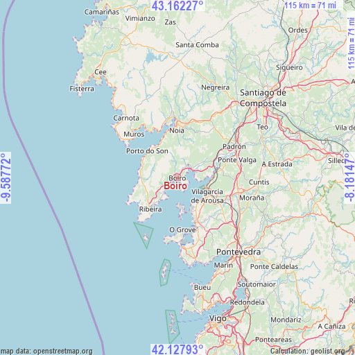
Boiro GPS coordinates[2]
42° 38' 50.1" North, 8° 53' 4.524" West
| Map corner | latitude | longitude |
|---|---|---|
| Upper-left | 43.16227°, | -9.58772° |
| Center: | 42.64725°, | -8.88459° |
| Lower-right: | 42.12793°, | -8.18147° |
| Map W x H: | 115×115 km | = 71.5×71.5mi |
| max Lat: | 43.74134° ⇑9.4% North |
| Boiro: | 42.64725° |
| min Lat: | ⇓90.6% South 27.64134° |
| min Long | Boiro | max Long |
| -18.00367° | -8.88459° | 4.2899° |
| W 1.9%⇐ | ⇒98.1% E |
Elevation
Elevation of Boiro is 29 m = 95 ft, and this is 569 m = 1867 ft below average elevation for this country.
| Max E: |
1682 m = 5518 ft | 94.3% |
| Avg. | 598 m = 1962 ft | |
| Boiro | 29 m = 95 ft | |
Min E: |
0 m = 0 ft | 5.7% |
See also: Spain elevation on elevation.city.
Geographical zone
Boiro is located in North temperate zone (between Tropic of Cancer and the Arctic Circle). Distance of this Northern Tropic circle is 2136 km =1327.2 mi to South.| Distance of | km | miles | from Boiro |
|---|---|---|---|
| North Pole | 5265.1 | 3271.6 | to North |
| Arctic Circle | 2659.2 | 1652.3 | to North |
| Tropic Cancer | 2136 | 1327.2 | to South |
| Equator | 4741.9 | 2946.5 | to South |


Nearby cities:
15 places around Boiro: (largest is in red/bold)
• A Pobra do Caramiñal
6.6 km =4.1 mi,  221°
221°
• Catoira
13.4 km =8.3 mi,  80°
80°
• Illa de Arousa
9.3 km =5.8 mi,  173°
173°
• Lousame
13.4 km =8.3 mi,  12°
12°
• Noia
15.4 km =9.6 mi,  359°
359°
• Oleiros
10.8 km =6.7 mi,  240°
240°
• Palmeira
8.9 km =5.5 mi, 216°
• Porto do Son
13.1 km =8.1 mi,  311°
311°
• Portosin
13.4 km =8.3 mi,  336°
336°
• Rianxo
5.5 km =3.4 mi,  87°
87°
• Santa Uxía de Ribeira
13.6 km =8.5 mi, 219°
• Sobradelo
10.9 km =6.8 mi,  130°
130°
• Vilagarcía de Arousa
11.4 km =7.1 mi,  119°
119°
• Vilanova de Arousa
10.4 km =6.5 mi,  153°
153°
• Vilaxoán
10.3 km =6.4 mi, 133°
Sources, notices
• [Note1] Compared only with cities in Spain existing in our database
• [Src1] Map data: © OpenStreetMap contributors (CC-BY-SA)
• [Src2] Other city data from geonames.org with taken over terms of usage.
• [Src3] Geographical zone / Annual Mean Temperature by Robert A. Rohde @ Wikipedia
