Avellanosa de Muñó geodata
Avellanosa de Muñó (Castille and León) is a seat of a third-order administrative division; located in Spain in Europe/Madrid (GMT+2) time zone. With population of 142 people, there are 5486 cities with bigger population in this country. Compared to other cities in Spain, 73.3% of cities are located further ↓South; 57.2% of cities are located further →East and 77.2% of cities have lower elevation than Avellanosa de Muñó. Note1
Administrative division(s):
- Level 1: Castille and León
- Level 2: Provincia de Burgos
- Level 3: Avellanosa de Muñó


Avellanosa de Muñó GPS coordinates[2]
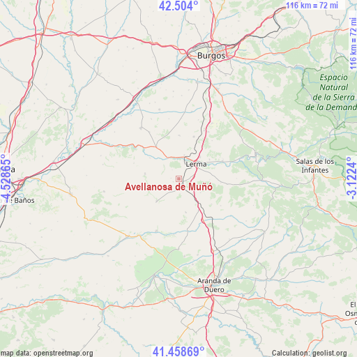
41° 59' 0.564" North, 3° 49' 31.908" West
| Map corner | latitude | longitude |
|---|---|---|
| Upper-left | 42.504°, | -4.52865° |
| Center: | 41.98349°, | -3.82553° |
| Lower-right: | 41.45869°, | -3.1224° |
| Map W x H: | 116.2×116.2 km | = 72.2×72.2mi |
| max Lat: | 43.74134° ⇑26.7% North |
| Avellanosa de Muñó: | 41.98349° |
| min Lat: | ⇓73.3% South 27.64134° |
| min Long | Avellanosa de M | max Long |
| -18.00367° | -3.82553° | 4.2899° |
| W 42.8%⇐ | ⇒57.2% E |
Elevation
Elevation of Avellanosa de Muñó is 872 m = 2861 ft, and this is 274 m = 899 ft above average elevation for this country.
| Max E: |
1682 m = 5518 ft | 22.8% |
| Avellanosa de Muñó | 872 m 2861 ft | |
| Avg. | 598 m = 1962 ft | |
Min E: |
0 m = 0 ft | 77.2% |
See also: Spain elevation on elevation.city.
Geographical zone
Avellanosa de Muñó is located in North temperate zone (between Tropic of Cancer and the Arctic Circle). Distance of this Northern Tropic circle is 2062.2 km =1281.4 mi to South.| Distance of | km | miles | from Avellanosa de Muñó |
|---|---|---|---|
| North Pole | 5338.9 | 3317.4 | to North |
| Arctic Circle | 2733 | 1698.2 | to North |
| Tropic Cancer | 2062.2 | 1281.4 | to South |
| Equator | 4668.1 | 2900.6 | to South |


Nearby cities:
15 places around Avellanosa de Muñó: (largest is in red/bold)
• Cilleruelo de Abajo
11.3 km =7 mi,  168°
168°
• Espinosa de Cerrato
10.7 km =6.6 mi,  260°
260°
• Fontioso
8.5 km =5.3 mi,  122°
122°
• Iglesiarrubia
2.1 km =1.3 mi,  238°
238°
• Lerma
7.2 km =4.5 mi,  48°
48°
• Quintanilla de la Mata
4.8 km =3 mi,  83°
83°
• Royuela de Río Franco
10.9 km =6.8 mi,  280°
280°
• Santa Cecilia
7.9 km =4.9 mi,  13°
13°
• Santa Inés
11.9 km =7.4 mi,  58°
58°
• Solarana
13.8 km =8.6 mi,  95°
95°
• Tordómar
7.7 km =4.8 mi,  334°
334°
• Villafruela
10.4 km =6.5 mi,  224°
224°
• Villahoz
12.6 km =7.8 mi,  324°
324°
• Villalmanzo
10 km =6.2 mi,  43°
43°
• Zael
13.6 km =8.5 mi,  359°
359°
Sources, notices
• [Note1] Compared only with cities in Spain existing in our database
• [Src1] Map data: © OpenStreetMap contributors (CC-BY-SA)
• [Src2] Other city data from geonames.org with taken over terms of usage.
• [Src3] Geographical zone / Annual Mean Temperature by Robert A. Rohde @ Wikipedia
