Iglesiarrubia geodata
Iglesiarrubia (Castille and León) is a seat of a third-order administrative division; located in Spain in Europe/Madrid (GMT+2) time zone. With population of 60 people, there are 6350 cities with bigger population in this country. Compared to other cities in Spain, 73% of cities are located further ↓South; 57.5% of cities are located further →East and 79% of cities have lower elevation than Iglesiarrubia. Note1
Administrative division(s):
- Level 1: Castille and León
- Level 2: Provincia de Burgos
- Level 3: Iglesiarrubia


Iglesiarrubia GPS coordinates[2]
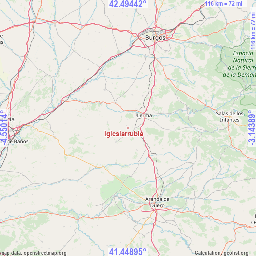
41° 58' 25.788" North, 3° 50' 49.236" West
| Map corner | latitude | longitude |
|---|---|---|
| Upper-left | 42.49442°, | -4.55014° |
| Center: | 41.97383°, | -3.84701° |
| Lower-right: | 41.44895°, | -3.14389° |
| Map W x H: | 116.2×116.2 km | = 72.2×72.2mi |
| max Lat: | 43.74134° ⇑27% North |
| Iglesiarrubia: | 41.97383° |
| min Lat: | ⇓73% South 27.64134° |
| min Long | Iglesiarrubia | max Long |
| -18.00367° | -3.84701° | 4.2899° |
| W 42.5%⇐ | ⇒57.5% E |
Elevation
Elevation of Iglesiarrubia is 889 m = 2917 ft, and this is 291 m = 955 ft above average elevation for this country.
| Max E: |
1682 m = 5518 ft | 21% |
| Iglesiarrubia | 889 m 2917 ft | |
| Avg. | 598 m = 1962 ft | |
Min E: |
0 m = 0 ft | 79% |
See also: Spain elevation on elevation.city.
Geographical zone
Iglesiarrubia is located in North temperate zone (between Tropic of Cancer and the Arctic Circle). Distance of this Northern Tropic circle is 2061.1 km =1280.7 mi to South.| Distance of | km | miles | from Iglesiarrubia |
|---|---|---|---|
| North Pole | 5340 | 3318.1 | to North |
| Arctic Circle | 2734.1 | 1698.9 | to North |
| Tropic Cancer | 2061.1 | 1280.7 | to South |
| Equator | 4667.1 | 2900 | to South |


Nearby cities:
15 places around Iglesiarrubia: (largest is in red/bold)
• Avellanosa de Muñó
2.1 km =1.3 mi,  58°
58°
• Cilleruelo de Abajo
10.8 km =6.7 mi,  157°
157°
• Cobos de Cerrato
14.2 km =8.8 mi,  295°
295°
• Espinosa de Cerrato
8.8 km =5.5 mi,  264°
264°
• Fontioso
9.6 km =6 mi,  111°
111°
• Lerma
9.3 km =5.8 mi,  51°
51°
• Quintanilla de la Mata
6.8 km =4.2 mi,  76°
76°
• Royuela de Río Franco
9.5 km =5.9 mi,  289°
289°
• Santa Cecilia
9.4 km =5.8 mi,  22°
22°
• Santa Inés
14 km =8.7 mi, 58°
• Tordómar
8.2 km =5.1 mi,  349°
349°
• Villafruela
8.4 km =5.2 mi,  220°
220°
• Villahoz
12.6 km =7.8 mi,  334°
334°
• Villalmanzo
12 km =7.5 mi, 46°
• Zael
14.8 km =9.2 mi,  6°
6°
Sources, notices
• [Note1] Compared only with cities in Spain existing in our database
• [Src1] Map data: © OpenStreetMap contributors (CC-BY-SA)
• [Src2] Other city data from geonames.org with taken over terms of usage.
• [Src3] Geographical zone / Annual Mean Temperature by Robert A. Rohde @ Wikipedia
