Santacara geodata
Santacara (Navarre) is a populated place; located in Spain in Europe/Madrid (GMT+2) time zone. With population of 1,017 people, there are 2918 cities with bigger population in this country. Compared to other cities in Spain, 83.7% of cities are located further ↓South; 71.6% of cities are located further ←West and 74.1% of cities have higher elevation than Santacara. Note1
Administrative division(s):
- Level 1: Navarre
- Level 2: Provincia de Navarra
- Level 3: Murillo el Cuende


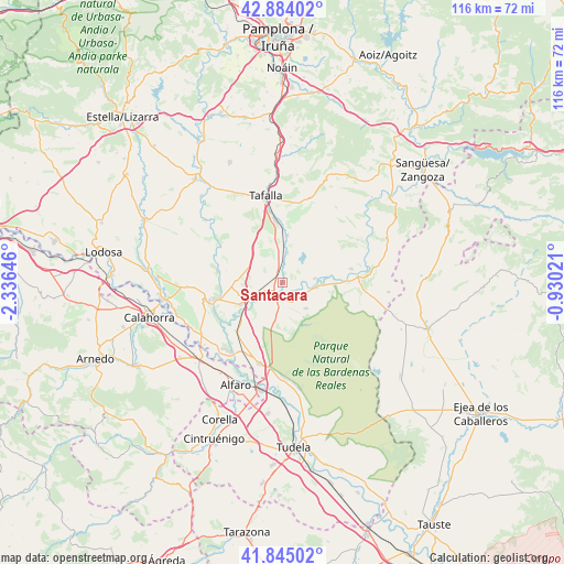
Santacara GPS coordinates[2]
42° 22' 0.012" North, 1° 37' 59.988" West
| Map corner | latitude | longitude |
|---|---|---|
| Upper-left | 42.88402°, | -2.33646° |
| Center: | 42.36667°, | -1.63333° |
| Lower-right: | 41.84502°, | -0.93021° |
| Map W x H: | 115.5×115.5 km | = 71.8×71.8mi |
| max Lat: | 43.74134° ⇑16.3% North |
| Santacara: | 42.36667° |
| min Lat: | ⇓83.7% South 27.64134° |
| min Long | Santacara | max Long |
| -18.00367° | -1.63333° | 4.2899° |
| W 71.6%⇐ | ⇒28.4% E |
Elevation
Elevation of Santacara is 313 m = 1027 ft, and this is 285 m = 935 ft below average elevation for this country.
| Max E: |
1682 m = 5518 ft | 74.1% |
| Avg. | 598 m = 1962 ft | |
| Santacara | 313 m = 1027 ft | |
Min E: |
0 m = 0 ft | 25.9% |
See also: Spain elevation on elevation.city.
Geographical zone
Santacara is located in North temperate zone (between Tropic of Cancer and the Arctic Circle). Distance of this Northern Tropic circle is 2104.8 km =1307.9 mi to South.| Distance of | km | miles | from Santacara |
|---|---|---|---|
| North Pole | 5296.3 | 3291 | to North |
| Arctic Circle | 2690.4 | 1671.7 | to North |
| Tropic Cancer | 2104.8 | 1307.9 | to South |
| Equator | 4710.7 | 2927.1 | to South |


Nearby cities:
15 places around Santacara: (largest is in red/bold)
• Andosilla
3.7 km =2.3 mi,  296°
296°
• Beire
9.8 km =6.1 mi,  5°
5°
• Cadreita
17.2 km =10.7 mi,  193°
193°
• Caparroso
3.1 km =1.9 mi,  205°
205°
• Carcastillo
15.6 km =9.7 mi,  84°
84°
• Falces
13.4 km =8.3 mi,  281°
281°
• Funes
14.8 km =9.2 mi,  247°
247°
• Marcilla
9.6 km =6 mi,  243°
243°
• Murillo el Cuende
3.3 km =2.1 mi, 5°
• Murillo el Fruto
14.5 km =9 mi, 78°
• Mélida
7 km =4.3 mi,  97°
97°
• Olite
12.7 km =7.9 mi,  353°
353°
• Peralta
14.1 km =8.8 mi,  257°
257°
• Pitillas
6.2 km =3.9 mi, 10°
• Villafranca
13.4 km =8.3 mi,  223°
223°
Sources, notices
• [Note1] Compared only with cities in Spain existing in our database
• [Src1] Map data: © OpenStreetMap contributors (CC-BY-SA)
• [Src2] Other city data from geonames.org with taken over terms of usage.
• [Src3] Geographical zone / Annual Mean Temperature by Robert A. Rohde @ Wikipedia
