Falces geodata
Falces (Navarre) is a seat of a third-order administrative division; located in Spain in Europe/Madrid (GMT+2) time zone. With population of 2,605 people, there are 1863 cities with bigger population in this country. Compared to other cities in Spain, 84.4% of cities are located further ↓South; 69.6% of cities are located further ←West and 75.5% of cities have higher elevation than Falces. Note1


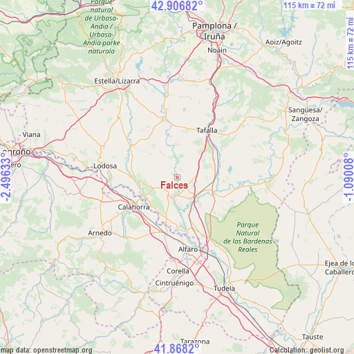
Falces GPS coordinates[2]
42° 23' 22.776" North, 1° 47' 35.556" West
| Map corner | latitude | longitude |
|---|---|---|
| Upper-left | 42.90682°, | -2.49633° |
| Center: | 42.38966°, | -1.79321° |
| Lower-right: | 41.8682°, | -1.09008° |
| Map W x H: | 115.5×115.5 km | = 71.8×71.8mi |
| max Lat: | 43.74134° ⇑15.6% North |
| Falces: | 42.38966° |
| min Lat: | ⇓84.4% South 27.64134° |
| min Long | Falces | max Long |
| -18.00367° | -1.79321° | 4.2899° |
| W 69.6%⇐ | ⇒30.4% E |
Elevation
Elevation of Falces is 291 m = 955 ft, and this is 307 m = 1007 ft below average elevation for this country.
| Max E: |
1682 m = 5518 ft | 75.5% |
| Avg. | 598 m = 1962 ft | |
| Falces | 291 m = 955 ft | |
Min E: |
0 m = 0 ft | 24.5% |
See also: Spain elevation on elevation.city.
Geographical zone
Falces is located in North temperate zone (between Tropic of Cancer and the Arctic Circle). Distance of this Northern Tropic circle is 2107.4 km =1309.5 mi to South.| Distance of | km | miles | from Falces |
|---|---|---|---|
| North Pole | 5293.8 | 3289.4 | to North |
| Arctic Circle | 2687.9 | 1670.2 | to North |
| Tropic Cancer | 2107.4 | 1309.5 | to South |
| Equator | 4713.3 | 2928.7 | to South |


Nearby cities:
15 places around Falces: (largest is in red/bold)
• Andosilla
9.9 km =6.2 mi,  95°
95°
• Andosilla
12.4 km =7.7 mi,  263°
263°
• Azagra
13.3 km =8.3 mi,  221°
221°
• Caparroso
13 km =8.1 mi,  114°
114°
• Cárcar
15.3 km =9.5 mi,  271°
271°
• Funes
8.3 km =5.2 mi,  183°
183°
• Marcilla
8.3 km =5.2 mi,  146°
146°
• Miranda de Arga
10.8 km =6.7 mi,  344°
344°
• Murillo el Cuende
13.5 km =8.4 mi,  86°
86°
• Olite
15.3 km =9.5 mi,  49°
49°
• Peralta
5.7 km =3.5 mi,  185°
185°
• Pitillas
14.6 km =9.1 mi,  75°
75°
• San Adrián
13.2 km =8.2 mi,  242°
242°
• Santacara
13.4 km =8.3 mi, 101°
• Villafranca
12.9 km =8 mi,  162°
162°
Sources, notices
• [Note1] Compared only with cities in Spain existing in our database
• [Src1] Map data: © OpenStreetMap contributors (CC-BY-SA)
• [Src2] Other city data from geonames.org with taken over terms of usage.
• [Src3] Geographical zone / Annual Mean Temperature by Robert A. Rohde @ Wikipedia
