Olite geodata
Olite (Navarre) is a seat of a third-order administrative division; located in Spain in Europe/Madrid (GMT+2) time zone. With population of 3,431 people, there are 1604 cities with bigger population in this country. Compared to other cities in Spain, 86.7% of cities are located further ↓South; 71.3% of cities are located further ←West and 69.3% of cities have higher elevation than Olite. Note1


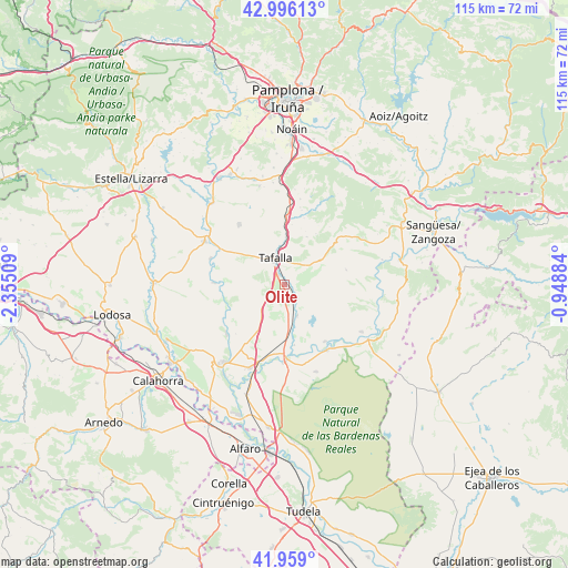
Olite GPS coordinates[2]
42° 28' 46.956" North, 1° 39' 7.056" West
| Map corner | latitude | longitude |
|---|---|---|
| Upper-left | 42.99613°, | -2.35509° |
| Center: | 42.47971°, | -1.65196° |
| Lower-right: | 41.959°, | -0.94884° |
| Map W x H: | 115.3×115.3 km | = 71.6×71.6mi |
| max Lat: | 43.74134° ⇑13.3% North |
| Olite: | 42.47971° |
| min Lat: | ⇓86.7% South 27.64134° |
| min Long | Olite | max Long |
| -18.00367° | -1.65196° | 4.2899° |
| W 71.3%⇐ | ⇒28.7% E |
Elevation
Elevation of Olite is 394 m = 1293 ft, and this is 204 m = 669 ft below average elevation for this country.
| Max E: |
1682 m = 5518 ft | 69.3% |
| Avg. | 598 m = 1962 ft | |
| Olite | 394 m = 1293 ft | |
Min E: |
0 m = 0 ft | 30.7% |
See also: Spain elevation on elevation.city.
Geographical zone
Olite is located in North temperate zone (between Tropic of Cancer and the Arctic Circle). Distance of this Northern Tropic circle is 2117.4 km =1315.7 mi to South.| Distance of | km | miles | from Olite |
|---|---|---|---|
| North Pole | 5283.8 | 3283.2 | to North |
| Arctic Circle | 2677.9 | 1664 | to North |
| Tropic Cancer | 2117.4 | 1315.7 | to South |
| Equator | 4723.3 | 2934.9 | to South |


Nearby cities:
15 places around Olite: (largest is in red/bold)
• Andosilla
11.1 km =6.9 mi,  189°
189°
• Artajona
15.3 km =9.5 mi,  322°
322°
• Barásoain
13.8 km =8.6 mi,  1°
1°
• Beire
3.8 km =2.4 mi,  138°
138°
• Falces
15.3 km =9.5 mi,  229°
229°
• Garínoain
13.4 km =8.3 mi, 2°
• Miranda de Arga
14.4 km =8.9 mi,  271°
271°
• Murillo el Cuende
9.4 km =5.8 mi,  168°
168°
• Orísoain
14.1 km =8.8 mi,  16°
16°
• Pitillas
7 km =4.3 mi,  157°
157°
• Pueyo
9.5 km =5.9 mi, 1°
• San Martín de Unx
9 km =5.6 mi,  56°
56°
• Santacara
12.7 km =7.9 mi, 173°
• Tafalla
5.6 km =3.5 mi,  340°
340°
• Ujué
12.7 km =7.9 mi,  79°
79°
Sources, notices
• [Note1] Compared only with cities in Spain existing in our database
• [Src1] Map data: © OpenStreetMap contributors (CC-BY-SA)
• [Src2] Other city data from geonames.org with taken over terms of usage.
• [Src3] Geographical zone / Annual Mean Temperature by Robert A. Rohde @ Wikipedia
