Andosilla geodata
Andosilla (Navarre) is a populated place; located in Spain in Europe/Madrid (GMT+2) time zone. With population of 2,830 people, there are 1777 cities with bigger population in this country. Compared to other cities in Spain, 84.2% of cities are located further ↓South; 71.1% of cities are located further ←West and 73% of cities have higher elevation than Andosilla. Note1


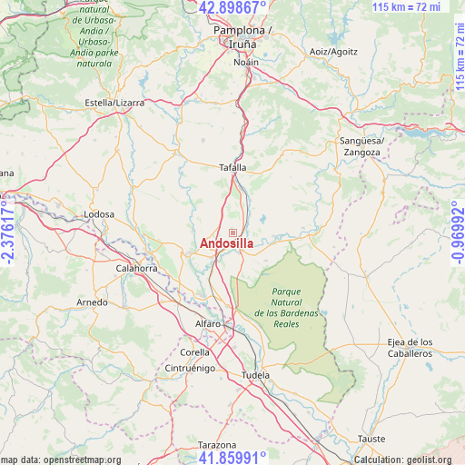
Andosilla GPS coordinates[2]
42° 22' 53.184" North, 1° 40' 22.98" West
| Map corner | latitude | longitude |
|---|---|---|
| Upper-left | 42.89867°, | -2.37617° |
| Center: | 42.38144°, | -1.67305° |
| Lower-right: | 41.85991°, | -0.96992° |
| Map W x H: | 115.5×115.5 km | = 71.8×71.8mi |
| max Lat: | 43.74134° ⇑15.8% North |
| Andosilla: | 42.38144° |
| min Lat: | ⇓84.2% South 27.64134° |
| min Long | Andosilla | max Long |
| -18.00367° | -1.67305° | 4.2899° |
| W 71.1%⇐ | ⇒28.9% E |
Elevation
Elevation of Andosilla is 333 m = 1093 ft, and this is 265 m = 869 ft below average elevation for this country.
| Max E: |
1682 m = 5518 ft | 73% |
| Avg. | 598 m = 1962 ft | |
| Andosilla | 333 m = 1093 ft | |
Min E: |
0 m = 0 ft | 27% |
See also: Spain elevation on elevation.city.
Geographical zone
Andosilla is located in North temperate zone (between Tropic of Cancer and the Arctic Circle). Distance of this Northern Tropic circle is 2106.5 km =1308.9 mi to South.| Distance of | km | miles | from Andosilla |
|---|---|---|---|
| North Pole | 5294.7 | 3290 | to North |
| Arctic Circle | 2688.8 | 1670.7 | to North |
| Tropic Cancer | 2106.5 | 1308.9 | to South |
| Equator | 4712.4 | 2928.1 | to South |


Nearby cities:
15 places around Andosilla: (largest is in red/bold)
• Beire
9.1 km =5.7 mi,  27°
27°
• Caparroso
4.9 km =3 mi,  156°
156°
• Falces
9.9 km =6.2 mi,  275°
275°
• Funes
12.8 km =8 mi,  234°
234°
• Marcilla
7.9 km =4.9 mi,  221°
221°
• Milagro
17.3 km =10.7 mi,  206°
206°
• Miranda de Arga
17 km =10.6 mi,  311°
311°
• Murillo el Cuende
3.9 km =2.4 mi,  64°
64°
• Mélida
10.5 km =6.5 mi,  103°
103°
• Olite
11.1 km =6.9 mi,  9°
9°
• Peralta
11.5 km =7.1 mi,  245°
245°
• Pitillas
6.2 km =3.9 mi,  44°
44°
• Santacara
3.7 km =2.3 mi,  116°
116°
• Tafalla
16.2 km =10.1 mi,  359°
359°
• Villafranca
12.9 km =8 mi, 207°
Sources, notices
• [Note1] Compared only with cities in Spain existing in our database
• [Src1] Map data: © OpenStreetMap contributors (CC-BY-SA)
• [Src2] Other city data from geonames.org with taken over terms of usage.
• [Src3] Geographical zone / Annual Mean Temperature by Robert A. Rohde @ Wikipedia
