Carcastillo geodata
Carcastillo (Navarre) is a seat of a third-order administrative division; located in Spain in Europe/Madrid (GMT+2) time zone. With population of 2,657 people, there are 1832 cities with bigger population in this country. Compared to other cities in Spain, 84.2% of cities are located further ↓South; 73.5% of cities are located further ←West and 71.7% of cities have higher elevation than Carcastillo. Note1


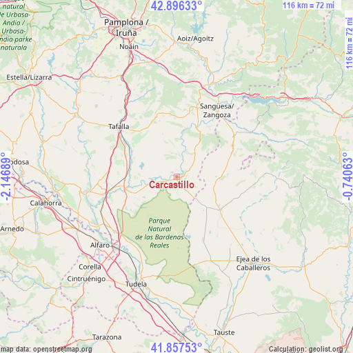
Carcastillo GPS coordinates[2]
42° 22' 44.688" North, 1° 26' 37.536" West
| Map corner | latitude | longitude |
|---|---|---|
| Upper-left | 42.89633°, | -2.14689° |
| Center: | 42.37908°, | -1.44376° |
| Lower-right: | 41.85753°, | -0.74063° |
| Map W x H: | 115.5×115.5 km | = 71.8×71.8mi |
| max Lat: | 43.74134° ⇑15.8% North |
| Carcastillo: | 42.37908° |
| min Lat: | ⇓84.2% South 27.64134° |
| min Long | Carcastillo | max Long |
| -18.00367° | -1.44376° | 4.2899° |
| W 73.5%⇐ | ⇒26.5% E |
Elevation
Elevation of Carcastillo is 354 m = 1161 ft, and this is 244 m = 801 ft below average elevation for this country.
| Max E: |
1682 m = 5518 ft | 71.7% |
| Avg. | 598 m = 1962 ft | |
| Carcastillo | 354 m = 1161 ft | |
Min E: |
0 m = 0 ft | 28.3% |
See also: Spain elevation on elevation.city.
Geographical zone
Carcastillo is located in North temperate zone (between Tropic of Cancer and the Arctic Circle). Distance of this Northern Tropic circle is 2106.2 km =1308.7 mi to South.| Distance of | km | miles | from Carcastillo |
|---|---|---|---|
| North Pole | 5294.9 | 3290.1 | to North |
| Arctic Circle | 2689.1 | 1670.9 | to North |
| Tropic Cancer | 2106.2 | 1308.7 | to South |
| Equator | 4712.1 | 2928 | to South |


Nearby cities:
15 places around Carcastillo: (largest is in red/bold)
• Andosilla
18.8 km =11.7 mi,  270°
270°
• Beire
16.8 km =10.4 mi,  299°
299°
• Caparroso
17.4 km =10.8 mi,  256°
256°
• Castiliscar
14 km =8.7 mi,  91°
91°
• Cáseda
17.2 km =10.7 mi,  21°
21°
• Gallipienzo
16.4 km =10.2 mi,  9°
9°
• Layana
18.8 km =11.7 mi,  119°
119°
• Murillo el Cuende
15.4 km =9.6 mi,  277°
277°
• Murillo el Fruto
2 km =1.2 mi,  318°
318°
• Mélida
8.9 km =5.5 mi, 255°
• Pitillas
15.2 km =9.4 mi,  288°
288°
• San Martín de Unx
18.8 km =11.7 mi,  329°
329°
• Santacara
15.6 km =9.7 mi, 264°
• Sádaba
17.9 km =11.1 mi,  127°
127°
• Ujué
14.2 km =8.8 mi,  341°
341°
Sources, notices
• [Note1] Compared only with cities in Spain existing in our database
• [Src1] Map data: © OpenStreetMap contributors (CC-BY-SA)
• [Src2] Other city data from geonames.org with taken over terms of usage.
• [Src3] Geographical zone / Annual Mean Temperature by Robert A. Rohde @ Wikipedia
