Funes geodata
Funes (Navarre) is a seat of a third-order administrative division; located in Spain in Europe/Madrid (GMT+2) time zone. With population of 2,406 people, there are 1939 cities with bigger population in this country. Compared to other cities in Spain, 82.2% of cities are located further ↓South; 69.4% of cities are located further ←West and 76% of cities have higher elevation than Funes. Note1


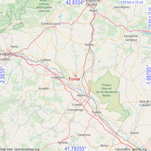
Funes GPS coordinates[2]
42° 18' 56.232" North, 1° 48' 0.612" West
| Map corner | latitude | longitude |
|---|---|---|
| Upper-left | 42.8334°, | -2.5033° |
| Center: | 42.31562°, | -1.80017° |
| Lower-right: | 41.79355°, | -1.09705° |
| Map W x H: | 115.6×115.6 km | = 71.8×71.8mi |
| max Lat: | 43.74134° ⇑17.8% North |
| Funes: | 42.31562° |
| min Lat: | ⇓82.2% South 27.64134° |
| min Long | Funes | max Long |
| -18.00367° | -1.80017° | 4.2899° |
| W 69.4%⇐ | ⇒30.6% E |
Elevation
Elevation of Funes is 285 m = 935 ft, and this is 313 m = 1027 ft below average elevation for this country.
| Max E: |
1682 m = 5518 ft | 76% |
| Avg. | 598 m = 1962 ft | |
| Funes | 285 m = 935 ft | |
Min E: |
0 m = 0 ft | 24% |
See also: Spain elevation on elevation.city.
Geographical zone
Funes is located in North temperate zone (between Tropic of Cancer and the Arctic Circle). Distance of this Northern Tropic circle is 2099.1 km =1304.3 mi to South.| Distance of | km | miles | from Funes |
|---|---|---|---|
| North Pole | 5302 | 3294.5 | to North |
| Arctic Circle | 2696.1 | 1675.3 | to North |
| Tropic Cancer | 2099.1 | 1304.3 | to South |
| Equator | 4705.1 | 2923.6 | to South |


Nearby cities:
15 places around Funes: (largest is in red/bold)
• Aldeanueva de Ebro
12 km =7.5 mi,  216°
216°
• Andosilla
12.8 km =8 mi,  54°
54°
• Andosilla
13.6 km =8.5 mi,  300°
300°
• Azagra
8.4 km =5.2 mi,  258°
258°
• Cadreita
14.6 km =9.1 mi,  138°
138°
• Calahorra
13.6 km =8.5 mi,  265°
265°
• Caparroso
12.7 km =7.9 mi,  77°
77°
• Falces
8.3 km =5.2 mi,  3°
3°
• Marcilla
5.4 km =3.4 mi, 75°
• Milagro
8.7 km =5.4 mi,  161°
161°
• Peralta
2.5 km =1.6 mi,  359°
359°
• Rincón de Soto
10 km =6.2 mi,  205°
205°
• San Adrián
11.3 km =7 mi,  280°
280°
• Santacara
14.8 km =9.2 mi,  67°
67°
• Villafranca
6 km =3.7 mi,  132°
132°
Sources, notices
• [Note1] Compared only with cities in Spain existing in our database
• [Src1] Map data: © OpenStreetMap contributors (CC-BY-SA)
• [Src2] Other city data from geonames.org with taken over terms of usage.
• [Src3] Geographical zone / Annual Mean Temperature by Robert A. Rohde @ Wikipedia
