Sant Julià de Cerdanyola geodata
Sant Julià de Cerdanyola (Catalonia) is a populated place; located in Spain in Europe/Madrid (GMT+2) time zone. With population of 1,212 people, there are 2715 cities with bigger population in this country. Compared to other cities in Spain, 79.9% of cities are located further ↓South; 93% of cities are located further ←West and 86.1% of cities have lower elevation than Sant Julià de Cerdanyola. Note1
Administrative division(s):
- Level 1: Catalonia
- Level 2: Província de Barcelona
- Level 3: Guardiola de Berguedà
Current local time in Sant Julià de Cerdanyola:
12:06 AM, FridayDifference from your time zone: hours


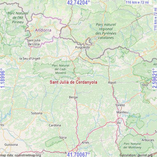
Sant Julià de Cerdanyola GPS coordinates[2]
42° 13' 24.6" North, 1° 53' 35.088" East
| Map corner | latitude | longitude |
|---|---|---|
| Upper-left | 42.74204°, | 1.18996° |
| Center: | 42.2235°, | 1.89308° |
| Lower-right: | 41.70067°, | 2.59621° |
| Map W x H: | 115.8×115.8 km | = 72×72mi |
| max Lat: | 43.74134° ⇑20.1% North |
| Sant Julià de Cerdanyola: | 42.2235° |
| min Lat: | ⇓79.9% South 27.64134° |
| min Long | Sant Julià de | max Long |
| -18.00367° | 1.89308° | 4.2899° |
| W 93%⇐ | ⇒7% E |
Elevation
Elevation of Sant Julià de Cerdanyola is 965 m = 3166 ft, and this is 367 m = 1204 ft above average elevation for this country.
| Max E: |
1682 m = 5518 ft | 13.9% |
| Sant Julià de Cerdanyola | 965 m 3166 ft | |
| Avg. | 598 m = 1962 ft | |
Min E: |
0 m = 0 ft | 86.1% |
See also: Spain elevation on elevation.city.
Geographical zone
Sant Julià de Cerdanyola is located in North temperate zone (between Tropic of Cancer and the Arctic Circle). Distance of this Northern Tropic circle is 2088.9 km =1298 mi to South.| Distance of | km | miles | from Sant Julià de Cerdanyola |
|---|---|---|---|
| North Pole | 5312.2 | 3300.8 | to North |
| Arctic Circle | 2706.4 | 1681.7 | to North |
| Tropic Cancer | 2088.9 | 1298 | to South |
| Equator | 4694.8 | 2917.2 | to South |


Nearby cities:
15 places around Sant Julià de Cerdanyola: (largest is in red/bold)
• Alp
16.6 km =10.3 mi,  358°
358°
• Bagà
4.2 km =2.6 mi,  321°
321°
• Berga
13.8 km =8.6 mi,  196°
196°
• Borredà
12.8 km =8 mi,  139°
139°
• Castellar del Riu
14.9 km =9.3 mi,  221°
221°
• Das
15.4 km =9.6 mi,  353°
353°
• Guardiola de Berguedà
1.8 km =1.1 mi,  314°
314°
• Olvan
17.4 km =10.8 mi,  178°
178°
• Riu de Cerdanya
14.6 km =9.1 mi,  337°
337°
• Saldes
13.2 km =8.2 mi,  274°
274°
• Sant Maurici de la Quar
16.7 km =10.4 mi,  158°
158°
• Toses
14.9 km =9.3 mi,  42°
42°
• Urús
14.6 km =9.1 mi, 347°
• Vallcebre
6.6 km =4.1 mi,  250°
250°
• Vilada
10.1 km =6.3 mi, 161°
Sources, notices
• [Note1] Compared only with cities in Spain existing in our database
• [Src1] Map data: © OpenStreetMap contributors (CC-BY-SA)
• [Src2] Other city data from geonames.org with taken over terms of usage.
• [Src3] Geographical zone / Annual Mean Temperature by Robert A. Rohde @ Wikipedia
