Castellar del Riu geodata
Castellar del Riu (Catalonia) is a seat of a third-order administrative division; located in Spain in Europe/Madrid (GMT+2) time zone. In our database, there are 6762 cities with bigger population. Compared to other cities in Spain, 77.2% of cities are located further ↓South; 92.5% of cities are located further ←West and 99.9% of cities have lower elevation than Castellar del Riu. Note1
Administrative division(s):
- Level 1: Catalonia
- Level 2: Província de Barcelona
- Level 3: Castellar del Riu


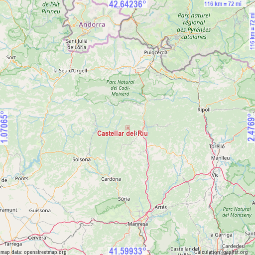
Castellar del Riu GPS coordinates[2]
42° 7' 22.764" North, 1° 46' 25.608" East
| Map corner | latitude | longitude |
|---|---|---|
| Upper-left | 42.64236°, | 1.07065° |
| Center: | 42.12299°, | 1.77378° |
| Lower-right: | 41.59933°, | 2.4769° |
| Map W x H: | 116×116 km | = 72.1×72.1mi |
| max Lat: | 43.74134° ⇑22.8% North |
| Castellar del Riu: | 42.12299° |
| min Lat: | ⇓77.2% South 27.64134° |
| min Long | Castellar del R | max Long |
| -18.00367° | 1.77378° | 4.2899° |
| W 92.5%⇐ | ⇒7.5% E |
Elevation
Elevation of Castellar del Riu is 1537 m = 5043 ft, and this is 939 m = 3081 ft above average elevation for this country.
| Max E: |
1682 m = 5518 ft | 0.099999999999994% |
| Castellar del Riu | 1537 m 5043 ft | |
| Avg. | 598 m = 1962 ft | |
Min E: |
0 m = 0 ft | 99.9% |
See also: Spain elevation on elevation.city.
Geographical zone
Castellar del Riu is located in North temperate zone (between Tropic of Cancer and the Arctic Circle). Distance of this Northern Tropic circle is 2077.7 km =1291 mi to South.| Distance of | km | miles | from Castellar del Riu |
|---|---|---|---|
| North Pole | 5323.4 | 3307.8 | to North |
| Arctic Circle | 2717.5 | 1688.6 | to North |
| Tropic Cancer | 2077.7 | 1291 | to South |
| Equator | 4683.6 | 2910.3 | to South |


Nearby cities:
15 places around Castellar del Riu: (largest is in red/bold)
• Avià
8.9 km =5.5 mi,  134°
134°
• Bagà
16.1 km =10 mi,  26°
26°
• Berga
6.3 km =3.9 mi,  109°
109°
• Borredà
18.2 km =11.3 mi,  85°
85°
• Capolat
5.4 km =3.4 mi,  198°
198°
• Gironella
13.2 km =8.2 mi,  138°
138°
• Guardiola de Berguedà
15.1 km =9.4 mi, 34°
• Gósol
15.8 km =9.8 mi,  323°
323°
• Olvan
12.2 km =7.6 mi,  121°
121°
• Sagàs
17.9 km =11.1 mi, 117°
• Saldes
12.7 km =7.9 mi,  344°
344°
• Sant Julià de Cerdanyola
14.9 km =9.3 mi,  41°
41°
• Sant Maurici de la Quar
16.5 km =10.3 mi, 105°
• Vallcebre
9.7 km =6 mi,  22°
22°
• Vilada
13.1 km =8.1 mi,  83°
83°
Sources, notices
• [Note1] Compared only with cities in Spain existing in our database
• [Src1] Map data: © OpenStreetMap contributors (CC-BY-SA)
• [Src2] Other city data from geonames.org with taken over terms of usage.
• [Src3] Geographical zone / Annual Mean Temperature by Robert A. Rohde @ Wikipedia
