Vallcebre geodata
Vallcebre (Catalonia) is a seat of a third-order administrative division; located in Spain in Europe/Madrid (GMT+2) time zone. In our database, there are 6762 cities with bigger population. Compared to other cities in Spain, 79.3% of cities are located further ↓South; 92.7% of cities are located further ←West and 94.5% of cities have lower elevation than Vallcebre. Note1


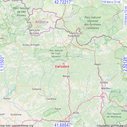
Vallcebre GPS coordinates[2]
42° 12' 12.492" North, 1° 49' 5.34" East
| Map corner | latitude | longitude |
|---|---|---|
| Upper-left | 42.72217°, | 1.11503° |
| Center: | 42.20347°, | 1.81815° |
| Lower-right: | 41.68047°, | 2.52128° |
| Map W x H: | 115.8×115.8 km | = 72×72mi |
| max Lat: | 43.74134° ⇑20.7% North |
| Vallcebre: | 42.20347° |
| min Lat: | ⇓79.3% South 27.64134° |
| min Long | Vallcebre | max Long |
| -18.00367° | 1.81815° | 4.2899° |
| W 92.7%⇐ | ⇒7.3% E |
Elevation
Elevation of Vallcebre is 1126 m = 3694 ft, and this is 528 m = 1732 ft above average elevation for this country.
| Max E: |
1682 m = 5518 ft | 5.5% |
| Vallcebre | 1126 m 3694 ft | |
| Avg. | 598 m = 1962 ft | |
Min E: |
0 m = 0 ft | 94.5% |
See also: Spain elevation on elevation.city.
Geographical zone
Vallcebre is located in North temperate zone (between Tropic of Cancer and the Arctic Circle). Distance of this Northern Tropic circle is 2086.7 km =1296.6 mi to South.| Distance of | km | miles | from Vallcebre |
|---|---|---|---|
| North Pole | 5314.5 | 3302.3 | to North |
| Arctic Circle | 2708.6 | 1683 | to North |
| Tropic Cancer | 2086.7 | 1296.6 | to South |
| Equator | 4692.6 | 2915.8 | to South |


Nearby cities:
15 places around Vallcebre: (largest is in red/bold)
• Avià
15.4 km =9.6 mi,  170°
170°
• Bagà
6.5 km =4 mi,  32°
32°
• Berga
11.3 km =7 mi, 168°
• Borredà
16.4 km =10.2 mi,  117°
117°
• Capolat
15 km =9.3 mi,  200°
200°
• Castellar del Riu
9.7 km =6 mi, 202°
• Das
18.1 km =11.2 mi,  13°
13°
• Guardiola de Berguedà
6 km =3.7 mi,  54°
54°
• Gósol
13.5 km =8.4 mi,  285°
285°
• Olvan
16.6 km =10.3 mi,  156°
156°
• Riu de Cerdanya
15.8 km =9.8 mi,  2°
2°
• Saldes
7.7 km =4.8 mi,  295°
295°
• Sant Julià de Cerdanyola
6.6 km =4.1 mi,  70°
70°
• Urús
16.7 km =10.4 mi, 10°
• Vilada
11.9 km =7.4 mi,  128°
128°
Sources, notices
• [Note1] Compared only with cities in Spain existing in our database
• [Src1] Map data: © OpenStreetMap contributors (CC-BY-SA)
• [Src2] Other city data from geonames.org with taken over terms of usage.
• [Src3] Geographical zone / Annual Mean Temperature by Robert A. Rohde @ Wikipedia
