San Fernando de Henares geodata
San Fernando de Henares (Madrid) is a seat of a third-order administrative division; located in Spain in Europe/Madrid (GMT+2) time zone. With population of 40,981 people, there are 215 cities with bigger population in this country. Compared to other cities in Spain, 63.5% of cities are located further ↑North; 52.7% of cities are located further →East and 55.6% of cities have higher elevation than San Fernando de Henares. Note1
Administrative division(s):
- Level 1: Madrid
- Level 2: Provincia de Madrid
- Level 3: San Fernando de Henares
Current local time in San Fernando de Henares:
09:15 PM, ThursdayDifference from your time zone: hours


San Fernando de Henares GPS coordinates[2]
40° 25' 25.896" North, 3° 31' 57.396" West
| Map corner | latitude | longitude |
|---|---|---|
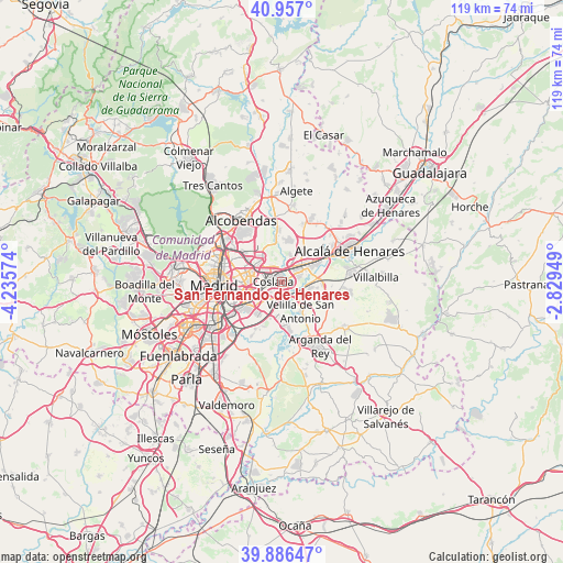
| Upper-left | 40.957°, | -4.23574° |
| Center: | 40.42386°, | -3.53261° |
| Lower-right: | 39.88647°, | -2.82949° |
| Map W x H: | 119×119 km | = 73.9×73.9mi |
| max Lat: | 43.74134° ⇑63.5% North |
| San Fernando de Henares: | 40.42386° |
| min Lat: | ⇓36.5% South 27.64134° |
| min Long | San Fernando de | max Long |
| -18.00367° | -3.53261° | 4.2899° |
| W 47.3%⇐ | ⇒52.7% E |
Elevation
Elevation of San Fernando de Henares is 588 m = 1929 ft, and this is 10 m = 33 ft below average elevation for this country.
| Max E: |
1682 m = 5518 ft | 55.6% |
| Avg. | 598 m = 1962 ft | |
| San Fernando de Henares | 588 m = 1929 ft | |
Min E: |
0 m = 0 ft | 44.4% |
See also: San Fernando de Henares elevation on elevation.city.
Geographical zone
San Fernando de Henares is located in North temperate zone (between Tropic of Cancer and the Arctic Circle). Distance of this Northern Tropic circle is 1888.8 km =1173.6 mi to South.| Distance of | km | miles | from San Fernando de Henares |
|---|---|---|---|
| North Pole | 5512.4 | 3425.2 | to North |
| Arctic Circle | 2906.5 | 1806 | to North |
| Tropic Cancer | 1888.8 | 1173.6 | to South |
| Equator | 4494.7 | 2792.9 | to South |


Nearby cities:
15 places around San Fernando de Henares: (largest is in red/bold)
• Barajas de Madrid
6.7 km =4.2 mi,  325°
325°
• Ciudad Lineal
10.3 km =6.4 mi,  283°
283°
• Coslada
2.4 km =1.5 mi,  269°
269°
• Hortaleza
10.8 km =6.7 mi,  301°
301°
• Loeches
11 km =6.8 mi,  114°
114°
• Mejorada del Campo
5.5 km =3.4 mi,  128°
128°
• Moratalaz
10.1 km =6.3 mi,  259°
259°
• Paracuellos de Jarama
8.9 km =5.5 mi,  2°
2°
• Puente de Vallecas
11.5 km =7.1 mi,  252°
252°
• Rivas-Vaciamadrid
11 km =6.8 mi,  170°
170°
• San Blas-Canillejas
7.2 km =4.5 mi, 283°
• Torrejón de Ardoz
6.4 km =4 mi,  56°
56°
• Velilla de San Antonio
7.7 km =4.8 mi,  148°
148°
• Vicálvaro
6.3 km =3.9 mi, 245°
• Villa de Vallecas
8.6 km =5.3 mi,  222°
222°
Sources, notices
• [Note1] Compared only with cities in Spain existing in our database
• [Src1] Map data: © OpenStreetMap contributors (CC-BY-SA)
• [Src2] Other city data from geonames.org with taken over terms of usage.
• [Src3] Geographical zone / Annual Mean Temperature by Robert A. Rohde @ Wikipedia
