Villa de Vallecas geodata
Villa de Vallecas (Madrid) is a section of populated place; located in Spain in Europe/Madrid (GMT+2) time zone. With population of 65,162 people, there are 143 cities with bigger population in this country. Compared to other cities in Spain, 64.6% of cities are located further ↑North; 53.7% of cities are located further →East and 51.5% of cities have higher elevation than Villa de Vallecas. Note1
Administrative division(s):
- Level 1: Madrid
- Level 2: Provincia de Madrid
- Level 3: Madrid
- Level 4: Villa de Vallecas


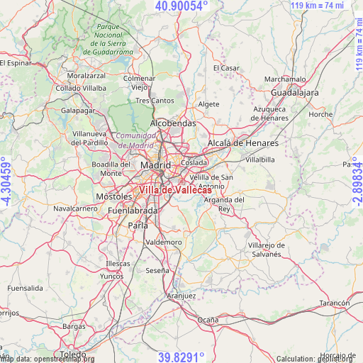
Villa de Vallecas GPS coordinates[2]
40° 22' 1.02" North, 3° 36' 5.256" West
| Map corner | latitude | longitude |
|---|---|---|
| Upper-left | 40.90054°, | -4.30459° |
| Center: | 40.36695°, | -3.60146° |
| Lower-right: | 39.8291°, | -2.89834° |
| Map W x H: | 119.1×119.1 km | = 74×74mi |
| max Lat: | 43.74134° ⇑64.6% North |
| Villa de Vallecas: | 40.36695° |
| min Lat: | ⇓35.4% South 27.64134° |
| min Long | Villa de Vallec | max Long |
| -18.00367° | -3.60146° | 4.2899° |
| W 46.3%⇐ | ⇒53.7% E |
Elevation
Elevation of Villa de Vallecas is 643 m = 2110 ft, and this is 45 m = 148 ft above average elevation for this country.
| Max E: |
1682 m = 5518 ft | 51.5% |
| Villa de Vallecas | 643 m 2110 ft | |
| Avg. | 598 m = 1962 ft | |
Min E: |
0 m = 0 ft | 48.5% |
See also: Villa de Vallecas elevation on elevation.city.
Geographical zone
Villa de Vallecas is located in North temperate zone (between Tropic of Cancer and the Arctic Circle). Distance of this Northern Tropic circle is 1882.5 km =1169.7 mi to South.| Distance of | km | miles | from Villa de Vallecas |
|---|---|---|---|
| North Pole | 5518.7 | 3429.2 | to North |
| Arctic Circle | 2912.8 | 1809.9 | to North |
| Tropic Cancer | 1882.5 | 1169.7 | to South |
| Equator | 4488.4 | 2789 | to South |


Nearby cities:
15 places around Villa de Vallecas: (largest is in red/bold)
• Arganzuela
8.8 km =5.5 mi,  294°
294°
• Ciudad Lineal
9.7 km =6 mi,  334°
334°
• Coslada
7.2 km =4.5 mi,  28°
28°
• Madrid
10.2 km =6.3 mi,  302°
302°
• Moratalaz
6.1 km =3.8 mi,  317°
317°
• Puente de Vallecas
5.9 km =3.7 mi, 299°
• Retiro
8.6 km =5.3 mi,  306°
306°
• Rivas-Vaciamadrid
8.9 km =5.5 mi,  120°
120°
• Salamanca
9.6 km =6 mi, 316°
• San Blas-Canillejas
8.1 km =5 mi,  351°
351°
• San Fernando de Henares
8.6 km =5.3 mi,  42°
42°
• Usera
8.7 km =5.4 mi, 286°
• Velilla de San Antonio
9.9 km =6.2 mi,  91°
91°
• Vicálvaro
3.7 km =2.3 mi,  1°
1°
• Villaverde
8.6 km =5.3 mi,  257°
257°
Sources, notices
• [Note1] Compared only with cities in Spain existing in our database
• [Src1] Map data: © OpenStreetMap contributors (CC-BY-SA)
• [Src2] Other city data from geonames.org with taken over terms of usage.
• [Src3] Geographical zone / Annual Mean Temperature by Robert A. Rohde @ Wikipedia
