Coslada geodata
Coslada (Madrid) is a seat of a third-order administrative division; located in Spain in Europe/Madrid (GMT+2) time zone. With population of 90,280 people, there are 97 cities with bigger population in this country. Compared to other cities in Spain, 63.5% of cities are located further ↑North; 53% of cities are located further →East and 53.4% of cities have higher elevation than Coslada. Note1


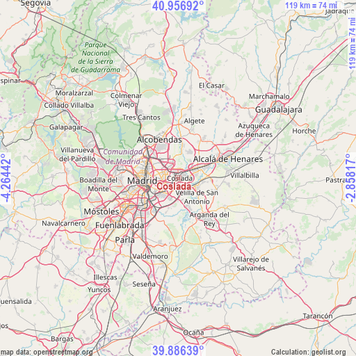
Coslada GPS coordinates[2]
40° 25' 25.608" North, 3° 33' 40.644" West
| Map corner | latitude | longitude |
|---|---|---|
| Upper-left | 40.95692°, | -4.26442° |
| Center: | 40.42378°, | -3.56129° |
| Lower-right: | 39.88639°, | -2.85817° |
| Map W x H: | 119×119 km | = 73.9×73.9mi |
| max Lat: | 43.74134° ⇑63.5% North |
| Coslada: | 40.42378° |
| min Lat: | ⇓36.5% South 27.64134° |
| min Long | Coslada | max Long |
| -18.00367° | -3.56129° | 4.2899° |
| W 47%⇐ | ⇒53% E |
Elevation
Elevation of Coslada is 619 m = 2031 ft, and this is 21 m = 69 ft above average elevation for this country.
| Max E: |
1682 m = 5518 ft | 53.4% |
| Coslada | 619 m 2031 ft | |
| Avg. | 598 m = 1962 ft | |
Min E: |
0 m = 0 ft | 46.6% |
See also: Coslada elevation on elevation.city.
Geographical zone
Coslada is located in North temperate zone (between Tropic of Cancer and the Arctic Circle). Distance of this Northern Tropic circle is 1888.8 km =1173.6 mi to South.| Distance of | km | miles | from Coslada |
|---|---|---|---|
| North Pole | 5512.4 | 3425.2 | to North |
| Arctic Circle | 2906.5 | 1806 | to North |
| Tropic Cancer | 1888.8 | 1173.6 | to South |
| Equator | 4494.7 | 2792.9 | to South |


Nearby cities:
15 places around Coslada: (largest is in red/bold)
• Barajas de Madrid
5.7 km =3.5 mi,  345°
345°
• Ciudad Lineal
8 km =5 mi,  287°
287°
• Hortaleza
8.8 km =5.5 mi,  309°
309°
• Mejorada del Campo
7.5 km =4.7 mi,  117°
117°
• Moratalaz
7.7 km =4.8 mi,  256°
256°
• Paracuellos de Jarama
9.3 km =5.8 mi,  17°
17°
• Puente de Vallecas
9.2 km =5.7 mi,  248°
248°
• Retiro
10.4 km =6.5 mi, 263°
• Salamanca
10 km =6.2 mi,  273°
273°
• San Blas-Canillejas
4.9 km =3 mi, 290°
• San Fernando de Henares
2.4 km =1.5 mi,  89°
89°
• Torrejón de Ardoz
8.5 km =5.3 mi,  65°
65°
• Velilla de San Antonio
9.2 km =5.7 mi,  135°
135°
• Vicálvaro
4.2 km =2.6 mi,  231°
231°
• Villa de Vallecas
7.2 km =4.5 mi,  208°
208°
Sources, notices
• [Note1] Compared only with cities in Spain existing in our database
• [Src1] Map data: © OpenStreetMap contributors (CC-BY-SA)
• [Src2] Other city data from geonames.org with taken over terms of usage.
• [Src3] Geographical zone / Annual Mean Temperature by Robert A. Rohde @ Wikipedia
