Vicálvaro geodata
Vicálvaro (Madrid) is a section of populated place; located in Spain in Europe/Madrid (GMT+2) time zone. With population of 66,439 people, there are 136 cities with bigger population in this country. Compared to other cities in Spain, 64% of cities are located further ↑North; 53.7% of cities are located further →East and 50.6% of cities have higher elevation than Vicálvaro. Note1
Administrative division(s):
- Level 1: Madrid
- Level 2: Provincia de Madrid
- Level 3: Madrid
- Level 4: Vicálvaro


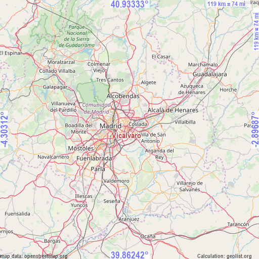
Vicálvaro GPS coordinates[2]
40° 24' 0" North, 3° 36' 0" West
| Map corner | latitude | longitude |
|---|---|---|
| Upper-left | 40.93333°, | -4.30312° |
| Center: | 40.4°, | -3.6° |
| Lower-right: | 39.86242°, | -2.89687° |
| Map W x H: | 119.1×119.1 km | = 74×74mi |
| max Lat: | 43.74134° ⇑64% North |
| Vicálvaro: | 40.4° |
| min Lat: | ⇓36% South 27.64134° |
| min Long | Vicálvaro | max Long |
| -18.00367° | -3.6° | 4.2899° |
| W 46.3%⇐ | ⇒53.7% E |
Elevation
Elevation of Vicálvaro is 651 m = 2136 ft, and this is 53 m = 174 ft above average elevation for this country.
| Max E: |
1682 m = 5518 ft | 50.6% |
| Vicálvaro | 651 m 2136 ft | |
| Avg. | 598 m = 1962 ft | |
Min E: |
0 m = 0 ft | 49.4% |
See also: Vicálvaro elevation on elevation.city.
Geographical zone
Vicálvaro is located in North temperate zone (between Tropic of Cancer and the Arctic Circle). Distance of this Northern Tropic circle is 1886.1 km =1172 mi to South.| Distance of | km | miles | from Vicálvaro |
|---|---|---|---|
| North Pole | 5515 | 3426.9 | to North |
| Arctic Circle | 2909.1 | 1807.6 | to North |
| Tropic Cancer | 1886.1 | 1172 | to South |
| Equator | 4492.1 | 2791.3 | to South |


Nearby cities:
15 places around Vicálvaro: (largest is in red/bold)
• Arganzuela
8.1 km =5 mi,  270°
270°
• Barajas de Madrid
8.4 km =5.2 mi,  12°
12°
• City Center
8.9 km =5.5 mi,  283°
283°
• Ciudad Lineal
6.6 km =4.1 mi,  319°
319°
• Coslada
4.2 km =2.6 mi,  51°
51°
• Hortaleza
9 km =5.6 mi,  337°
337°
• Madrid
8.9 km =5.5 mi, 281°
• Moratalaz
4.3 km =2.7 mi, 281°
• Puente de Vallecas
5.3 km =3.3 mi,  262°
262°
• Retiro
7.2 km =4.5 mi, 281°
• Salamanca
7.5 km =4.7 mi,  296°
296°
• San Blas-Canillejas
4.5 km =2.8 mi, 343°
• San Fernando de Henares
6.3 km =3.9 mi,  65°
65°
• Usera
8.6 km =5.3 mi, 261°
• Villa de Vallecas
3.7 km =2.3 mi,  181°
181°
Sources, notices
• [Note1] Compared only with cities in Spain existing in our database
• [Src1] Map data: © OpenStreetMap contributors (CC-BY-SA)
• [Src2] Other city data from geonames.org with taken over terms of usage.
• [Src3] Geographical zone / Annual Mean Temperature by Robert A. Rohde @ Wikipedia
