San Claudio geodata
San Claudio (Asturias) is a populated place; located in Spain in Europe/Madrid (GMT+1) time zone. With population of 534 people, there are 3774 cities with bigger population in this country. Compared to other cities in Spain, 98.2% of cities are located further ↓South; 84.9% of cities are located further →East and 81.8% of cities have higher elevation than San Claudio. Note1


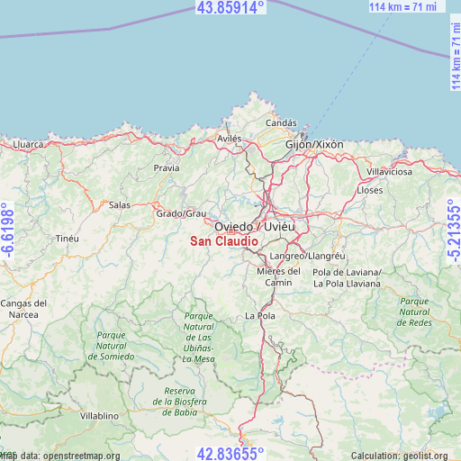
San Claudio GPS coordinates[2]
43° 21' 0" North, 5° 55' 0.012" West
| Map corner | latitude | longitude |
|---|---|---|
| Upper-left | 43.85914°, | -6.6198° |
| Center: | 43.35°, | -5.91667° |
| Lower-right: | 42.83655°, | -5.21355° |
| Map W x H: | 113.7×113.7 km | = 70.6×70.6mi |
| max Lat: | 43.74134° ⇑1.8% North |
| San Claudio: | 43.35° |
| min Lat: | ⇓98.2% South 27.64134° |
| min Long | San Claudio | max Long |
| -18.00367° | -5.91667° | 4.2899° |
| W 15.1%⇐ | ⇒84.9% E |
Elevation
Elevation of San Claudio is 190 m = 623 ft, and this is 408 m = 1339 ft below average elevation for this country.
| Max E: |
1682 m = 5518 ft | 81.8% |
| Avg. | 598 m = 1962 ft | |
| San Claudio | 190 m = 623 ft | |
Min E: |
0 m = 0 ft | 18.2% |
See also: Spain elevation on elevation.city.
Geographical zone
San Claudio is located in North temperate zone (between Tropic of Cancer and the Arctic Circle). Distance of this Northern Tropic circle is 2214.1 km =1375.8 mi to South.| Distance of | km | miles | from San Claudio |
|---|---|---|---|
| North Pole | 5187 | 3223.1 | to North |
| Arctic Circle | 2581.1 | 1603.8 | to North |
| Tropic Cancer | 2214.1 | 1375.8 | to South |
| Equator | 4820.1 | 2995.1 | to South |


Nearby cities:
15 places around San Claudio: (largest is in red/bold)
• Bárzana
21.9 km =13.6 mi,  192°
192°
• Castandiello
8.1 km =5 mi,  165°
165°
• Corvera de Asturias
20.8 km =12.9 mi,  6°
6°
• Grado
13.4 km =8.3 mi,  288°
288°
• Illas
17 km =10.6 mi,  343°
343°
• Llanera
9.6 km =6 mi,  16°
16°
• Llanera
12.5 km =7.8 mi,  354°
354°
• Lugones
10.3 km =6.4 mi,  55°
55°
• Mieres
16.5 km =10.3 mi,  132°
132°
• Noreña
17.7 km =11 mi,  74°
74°
• Oviedo
5.9 km =3.7 mi,  78°
78°
• Pola de Siero
21 km =13 mi, 77°
• Pravia
22 km =13.7 mi,  314°
314°
• Proaza
13.6 km =8.5 mi,  216°
216°
• Sama
19.8 km =12.3 mi,  107°
107°
Sources, notices
• [Note1] Compared only with cities in Spain existing in our database
• [Src1] Map data: © OpenStreetMap contributors (CC-BY-SA)
• [Src2] Other city data from geonames.org with taken over terms of usage.
• [Src3] Geographical zone / Annual Mean Temperature by Robert A. Rohde @ Wikipedia
