Mieres geodata
Mieres (Asturias) is a seat of a third-order administrative division; located in Spain in Europe/Madrid (GMT+2) time zone. With population of 44,070 people, there are 196 cities with bigger population in this country. Compared to other cities in Spain, 96.9% of cities are located further ↓South; 82.8% of cities are located further →East and 71% of cities have higher elevation than Mieres. Note1


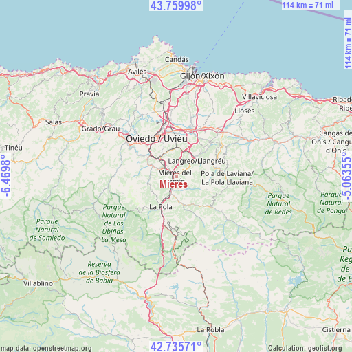
Mieres GPS coordinates[2]
43° 15' 0" North, 5° 46' 0.012" West
| Map corner | latitude | longitude |
|---|---|---|
| Upper-left | 43.75998°, | -6.4698° |
| Center: | 43.25°, | -5.76667° |
| Lower-right: | 42.73571°, | -5.06355° |
| Map W x H: | 113.9×113.9 km | = 70.8×70.8mi |
| max Lat: | 43.74134° ⇑3.1% North |
| Mieres: | 43.25° |
| min Lat: | ⇓96.9% South 27.64134° |
| min Long | Mieres | max Long |
| -18.00367° | -5.76667° | 4.2899° |
| W 17.2%⇐ | ⇒82.8% E |
Elevation
Elevation of Mieres is 367 m = 1204 ft, and this is 231 m = 758 ft below average elevation for this country.
| Max E: |
1682 m = 5518 ft | 71% |
| Avg. | 598 m = 1962 ft | |
| Mieres | 367 m = 1204 ft | |
Min E: |
0 m = 0 ft | 29% |
See also: Mieres elevation on elevation.city.
Geographical zone
Mieres is located in North temperate zone (between Tropic of Cancer and the Arctic Circle). Distance of this Northern Tropic circle is 2203 km =1368.9 mi to South.| Distance of | km | miles | from Mieres |
|---|---|---|---|
| North Pole | 5198.1 | 3229.9 | to North |
| Arctic Circle | 2592.2 | 1610.7 | to North |
| Tropic Cancer | 2203 | 1368.9 | to South |
| Equator | 4808.9 | 2988.1 | to South |


Nearby cities:
15 places around Mieres: (largest is in red/bold)
• Bimenes
19 km =11.8 mi,  67°
67°
• Bárzana
19.7 km =12.2 mi,  238°
238°
• Castandiello
10.7 km =6.6 mi,  287°
287°
• El entrego
11.2 km =7 mi, 68°
• Llanera
22.5 km =14 mi,  335°
335°
• Lugones
17.4 km =10.8 mi,  347°
347°
• Nava
24 km =14.9 mi,  59°
59°
• Noreña
16.7 km =10.4 mi,  16°
16°
• Oviedo
13.8 km =8.6 mi,  332°
332°
• Pola de Laviana
16.5 km =10.3 mi,  91°
91°
• Pola de Lena
11.1 km =6.9 mi,  206°
206°
• Pola de Siero
17.9 km =11.1 mi,  27°
27°
• Proaza
20.2 km =12.6 mi,  270°
270°
• Sama
8.4 km =5.2 mi,  52°
52°
• San Claudio
16.5 km =10.3 mi,  312°
312°
Sources, notices
• [Note1] Compared only with cities in Spain existing in our database
• [Src1] Map data: © OpenStreetMap contributors (CC-BY-SA)
• [Src2] Other city data from geonames.org with taken over terms of usage.
• [Src3] Geographical zone / Annual Mean Temperature by Robert A. Rohde @ Wikipedia
