Castandiello geodata
Castandiello (Asturias) is a populated place; located in Spain in Europe/Madrid (GMT+2) time zone. With population of 3,072 people, there are 1697 cities with bigger population in this country. Compared to other cities in Spain, 97.3% of cities are located further ↓South; 84.6% of cities are located further →East and 77.2% of cities have higher elevation than Castandiello. Note1


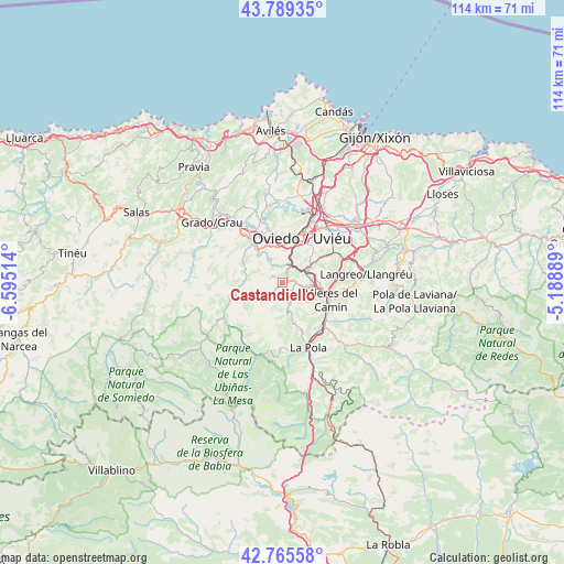
Castandiello GPS coordinates[2]
43° 16' 46.632" North, 5° 53' 31.236" West
| Map corner | latitude | longitude |
|---|---|---|
| Upper-left | 43.78935°, | -6.59514° |
| Center: | 43.27962°, | -5.89201° |
| Lower-right: | 42.76558°, | -5.18889° |
| Map W x H: | 113.8×113.8 km | = 70.7×70.7mi |
| max Lat: | 43.74134° ⇑2.7% North |
| Castandiello: | 43.27962° |
| min Lat: | ⇓97.3% South 27.64134° |
| min Long | Castandiello | max Long |
| -18.00367° | -5.89201° | 4.2899° |
| W 15.4%⇐ | ⇒84.6% E |
Elevation
Elevation of Castandiello is 267 m = 876 ft, and this is 331 m = 1086 ft below average elevation for this country.
| Max E: |
1682 m = 5518 ft | 77.2% |
| Avg. | 598 m = 1962 ft | |
| Castandiello | 267 m = 876 ft | |
Min E: |
0 m = 0 ft | 22.8% |
See also: Spain elevation on elevation.city.
Geographical zone
Castandiello is located in North temperate zone (between Tropic of Cancer and the Arctic Circle). Distance of this Northern Tropic circle is 2206.3 km =1370.9 mi to South.| Distance of | km | miles | from Castandiello |
|---|---|---|---|
| North Pole | 5194.8 | 3227.9 | to North |
| Arctic Circle | 2588.9 | 1608.7 | to North |
| Tropic Cancer | 2206.3 | 1370.9 | to South |
| Equator | 4812.2 | 2990.2 | to South |


Nearby cities:
15 places around Castandiello: (largest is in red/bold)
• Bárzana
15.1 km =9.4 mi,  205°
205°
• El entrego
20.6 km =12.8 mi,  87°
87°
• Grado
19 km =11.8 mi,  309°
309°
• La Plaza
21.2 km =13.2 mi,  232°
232°
• Llanera
17.1 km =10.6 mi,  2°
2°
• Llanera
20.5 km =12.7 mi,  351°
351°
• Lugones
15.1 km =9.4 mi,  25°
25°
• Mieres
10.7 km =6.6 mi,  107°
107°
• Noreña
19.6 km =12.2 mi,  49°
49°
• Oviedo
9.8 km =6.1 mi,  23°
23°
• Pola de Lena
14.2 km =8.8 mi,  158°
158°
• Pola de Siero
22.3 km =13.9 mi,  55°
55°
• Proaza
10.5 km =6.5 mi,  252°
252°
• Sama
16.9 km =10.5 mi,  83°
83°
• San Claudio
8.1 km =5 mi, 345°
Sources, notices
• [Note1] Compared only with cities in Spain existing in our database
• [Src1] Map data: © OpenStreetMap contributors (CC-BY-SA)
• [Src2] Other city data from geonames.org with taken over terms of usage.
• [Src3] Geographical zone / Annual Mean Temperature by Robert A. Rohde @ Wikipedia
