Oviedo geodata
Oviedo (Asturias) is a seat of a first-order administrative division; located in Spain in Europe/Madrid (GMT+2) time zone. With population of 224,005 people, there are 26 cities with bigger population in this country. Compared to other cities in Spain, 98.4% of cities are located further ↓South; 83.8% of cities are located further →East and 79.1% of cities have higher elevation than Oviedo. Note1


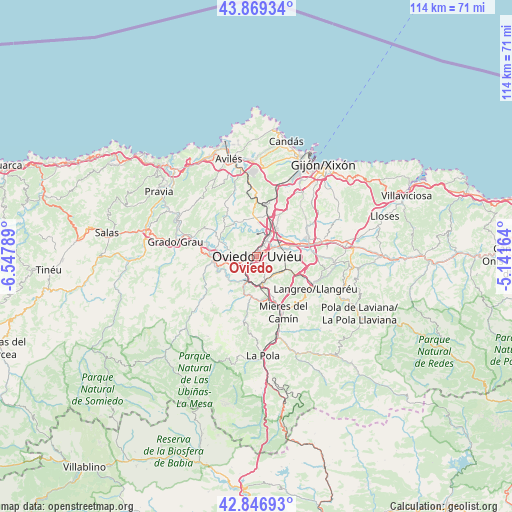
Oviedo GPS coordinates[2]
43° 21' 37.044" North, 5° 50' 41.136" West
| Map corner | latitude | longitude |
|---|---|---|
| Upper-left | 43.86934°, | -6.54789° |
| Center: | 43.36029°, | -5.84476° |
| Lower-right: | 42.84693°, | -5.14164° |
| Map W x H: | 113.7×113.7 km | = 70.6×70.6mi |
| max Lat: | 43.74134° ⇑1.6% North |
| Oviedo: | 43.36029° |
| min Lat: | ⇓98.4% South 27.64134° |
| min Long | Oviedo | max Long |
| -18.00367° | -5.84476° | 4.2899° |
| W 16.2%⇐ | ⇒83.8% E |
Elevation
Elevation of Oviedo is 237 m = 778 ft, and this is 361 m = 1184 ft below average elevation for this country.
| Max E: |
1682 m = 5518 ft | 79.1% |
| Avg. | 598 m = 1962 ft | |
| Oviedo | 237 m = 778 ft | |
Min E: |
0 m = 0 ft | 20.9% |
See also: Oviedo elevation on elevation.city.
Geographical zone
Oviedo is located in North temperate zone (between Tropic of Cancer and the Arctic Circle). Distance of this Northern Tropic circle is 2215.3 km =1376.5 mi to South.| Distance of | km | miles | from Oviedo |
|---|---|---|---|
| North Pole | 5185.8 | 3222.3 | to North |
| Arctic Circle | 2580 | 1603.1 | to North |
| Tropic Cancer | 2215.3 | 1376.5 | to South |
| Equator | 4821.2 | 2995.8 | to South |


Nearby cities:
15 places around Oviedo: (largest is in red/bold)
• Castandiello
9.8 km =6.1 mi,  203°
203°
• Corvera de Asturias
19.8 km =12.3 mi,  349°
349°
• El entrego
18.6 km =11.6 mi,  115°
115°
• Grado
18.8 km =11.7 mi,  279°
279°
• Illas
18.5 km =11.5 mi,  325°
325°
• Llanera
8.7 km =5.4 mi,  339°
339°
• Llanera
13.3 km =8.3 mi, 328°
• Lugones
5.4 km =3.4 mi,  29°
29°
• Mieres
13.8 km =8.6 mi,  152°
152°
• Noreña
11.8 km =7.3 mi,  71°
71°
• Pola de Lena
22.2 km =13.8 mi,  176°
176°
• Pola de Siero
15.1 km =9.4 mi,  76°
76°
• Proaza
18.4 km =11.4 mi,  229°
229°
• Sama
14.8 km =9.2 mi, 118°
• San Claudio
5.9 km =3.7 mi,  258°
258°
Sources, notices
• [Note1] Compared only with cities in Spain existing in our database
• [Src1] Map data: © OpenStreetMap contributors (CC-BY-SA)
• [Src2] Other city data from geonames.org with taken over terms of usage.
• [Src3] Geographical zone / Annual Mean Temperature by Robert A. Rohde @ Wikipedia
