San Agustín geodata
San Agustín (Aragon) is a seat of a third-order administrative division; located in Spain in Europe/Madrid (GMT+2) time zone. With population of 119 people, there are 5710 cities with bigger population in this country. Compared to other cities in Spain, 69.4% of cities are located further ↑North; 79.9% of cities are located further ←West and 81.5% of cities have lower elevation than San Agustín. Note1


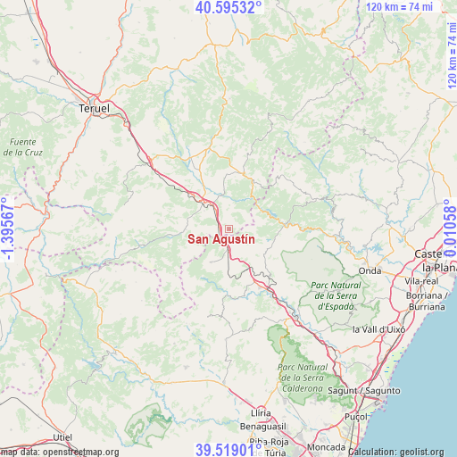
San Agustín GPS coordinates[2]
40° 3' 33.444" North, 0° 41' 33.144" West
| Map corner | latitude | longitude |
|---|---|---|
| Upper-left | 40.59532°, | -1.39567° |
| Center: | 40.05929°, | -0.69254° |
| Lower-right: | 39.51901°, | 0.01058° |
| Map W x H: | 119.7×119.7 km | = 74.4×74.4mi |
| max Lat: | 43.74134° ⇑69.4% North |
| San Agustín: | 40.05929° |
| min Lat: | ⇓30.6% South 27.64134° |
| min Long | San Agustín | max Long |
| -18.00367° | -0.69254° | 4.2899° |
| W 79.9%⇐ | ⇒20.1% E |
Elevation
Elevation of San Agustín is 912 m = 2992 ft, and this is 314 m = 1030 ft above average elevation for this country.
| Max E: |
1682 m = 5518 ft | 18.5% |
| San Agustín | 912 m 2992 ft | |
| Avg. | 598 m = 1962 ft | |
Min E: |
0 m = 0 ft | 81.5% |
See also: Spain elevation on elevation.city.
Geographical zone
San Agustín is located in North temperate zone (between Tropic of Cancer and the Arctic Circle). Distance of this Northern Tropic circle is 1848.3 km =1148.5 mi to South.| Distance of | km | miles | from San Agustín |
|---|---|---|---|
| North Pole | 5552.9 | 3450.4 | to North |
| Arctic Circle | 2947 | 1831.2 | to North |
| Tropic Cancer | 1848.3 | 1148.5 | to South |
| Equator | 4454.2 | 2767.7 | to South |


Nearby cities:
15 places around San Agustín: (largest is in red/bold)
• Albentosa
8 km =5 mi,  307°
307°
• Barracas
4.8 km =3 mi,  170°
170°
• Caudiel
16.2 km =10.1 mi,  138°
138°
• Fuente la Reina
7.9 km =4.9 mi,  84°
84°
• Fuentes de Rubielos
13.6 km =8.5 mi,  28°
28°
• Manzanera
12 km =7.5 mi,  265°
265°
• Montanejos
15 km =9.3 mi,  86°
86°
• Montán
12.5 km =7.8 mi,  103°
103°
• Olba
10.5 km =6.5 mi,  38°
38°
• Pina de Montalgrao
6 km =3.7 mi, 142°
• Puebla de Arenoso
10.3 km =6.4 mi,  64°
64°
• Rubielos de Mora
14.8 km =9.2 mi,  13°
13°
• Sarrión
13.9 km =8.6 mi, 311°
• Torás
15.9 km =9.9 mi,  177°
177°
• Villanueva de Viver
3.8 km =2.4 mi,  105°
105°
Sources, notices
• [Note1] Compared only with cities in Spain existing in our database
• [Src1] Map data: © OpenStreetMap contributors (CC-BY-SA)
• [Src2] Other city data from geonames.org with taken over terms of usage.
• [Src3] Geographical zone / Annual Mean Temperature by Robert A. Rohde @ Wikipedia
