Manzanera geodata
Manzanera (Aragon) is a seat of a third-order administrative division; located in Spain in Europe/Madrid (GMT+2) time zone. With population of 460 people, there are 3982 cities with bigger population in this country. Compared to other cities in Spain, 69.6% of cities are located further ↑North; 78.5% of cities are located further ←West and 91.6% of cities have lower elevation than Manzanera. Note1


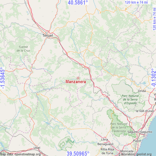
Manzanera GPS coordinates[2]
40° 3' 0" North, 0° 49' 59.988" West
| Map corner | latitude | longitude |
|---|---|---|
| Upper-left | 40.5861°, | -1.53645° |
| Center: | 40.05°, | -0.83333° |
| Lower-right: | 39.50965°, | -0.1302° |
| Map W x H: | 119.7×119.7 km | = 74.4×74.4mi |
| max Lat: | 43.74134° ⇑69.6% North |
| Manzanera: | 40.05° |
| min Lat: | ⇓30.4% South 27.64134° |
| min Long | Manzanera | max Long |
| -18.00367° | -0.83333° | 4.2899° |
| W 78.5%⇐ | ⇒21.5% E |
Elevation
Elevation of Manzanera is 1058 m = 3471 ft, and this is 460 m = 1509 ft above average elevation for this country.
| Max E: |
1682 m = 5518 ft | 8.4% |
| Manzanera | 1058 m 3471 ft | |
| Avg. | 598 m = 1962 ft | |
Min E: |
0 m = 0 ft | 91.6% |
See also: Spain elevation on elevation.city.
Geographical zone
Manzanera is located in North temperate zone (between Tropic of Cancer and the Arctic Circle). Distance of this Northern Tropic circle is 1847.2 km =1147.8 mi to South.| Distance of | km | miles | from Manzanera |
|---|---|---|---|
| North Pole | 5553.9 | 3451 | to North |
| Arctic Circle | 2948 | 1831.8 | to North |
| Tropic Cancer | 1847.2 | 1147.8 | to South |
| Equator | 4453.1 | 2767 | to South |


Nearby cities:
15 places around Manzanera: (largest is in red/bold)
• Albentosa
8.1 km =5 mi,  43°
43°
• Arcos de las Salinas
18.6 km =11.6 mi,  246°
246°
• Barracas
13.3 km =8.3 mi,  106°
106°
• Camarena de la Sierra
20.3 km =12.6 mi,  303°
303°
• Fuente la Reina
19.9 km =12.4 mi,  84°
84°
• La Puebla de Valverde
21 km =13 mi,  337°
337°
• La Yesa
21 km =13 mi,  208°
208°
• Olba
20.6 km =12.8 mi,  63°
63°
• Pina de Montalgrao
16 km =9.9 mi,  103°
103°
• San Agustín
12 km =7.5 mi,  85°
85°
• Sarrión
10.3 km =6.4 mi,  8°
8°
• Torrijas
10.6 km =6.6 mi, 249°
• Torás
19.6 km =12.2 mi,  139°
139°
• Valbona
20 km =12.4 mi, 5°
• Villanueva de Viver
15.6 km =9.7 mi, 90°
Sources, notices
• [Note1] Compared only with cities in Spain existing in our database
• [Src1] Map data: © OpenStreetMap contributors (CC-BY-SA)
• [Src2] Other city data from geonames.org with taken over terms of usage.
• [Src3] Geographical zone / Annual Mean Temperature by Robert A. Rohde @ Wikipedia
