Sanchonuño geodata
Sanchonuño (Castille and León) is a seat of a third-order administrative division; located in Spain in Europe/Madrid (GMT+2) time zone. With population of 837 people, there are 3150 cities with bigger population in this country. Compared to other cities in Spain, 55.7% of cities are located further ↓South; 63.9% of cities are located further →East and 69.1% of cities have lower elevation than Sanchonuño. Note1
Administrative division(s):
- Level 1: Castille and León
- Level 2: Provincia de Segovia
- Level 3: Sanchonuño


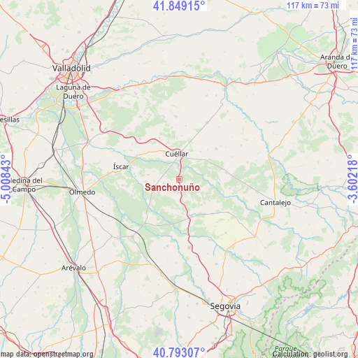
Sanchonuño GPS coordinates[2]
41° 19' 23.7" North, 4° 18' 19.116" West
| Map corner | latitude | longitude |
|---|---|---|
| Upper-left | 41.84915°, | -5.00843° |
| Center: | 41.32325°, | -4.30531° |
| Lower-right: | 40.79307°, | -3.60218° |
| Map W x H: | 117.4×117.4 km | = 72.9×72.9mi |
| max Lat: | 43.74134° ⇑44.3% North |
| Sanchonuño: | 41.32325° |
| min Lat: | ⇓55.7% South 27.64134° |
| min Long | Sanchonuño | max Long |
| -18.00367° | -4.30531° | 4.2899° |
| W 36.1%⇐ | ⇒63.9% E |
Elevation
Elevation of Sanchonuño is 807 m = 2648 ft, and this is 209 m = 686 ft above average elevation for this country.
| Max E: |
1682 m = 5518 ft | 30.9% |
| Sanchonuño | 807 m 2648 ft | |
| Avg. | 598 m = 1962 ft | |
Min E: |
0 m = 0 ft | 69.1% |
See also: Spain elevation on elevation.city.
Geographical zone
Sanchonuño is located in North temperate zone (between Tropic of Cancer and the Arctic Circle). Distance of this Northern Tropic circle is 1988.8 km =1235.8 mi to South.| Distance of | km | miles | from Sanchonuño |
|---|---|---|---|
| North Pole | 5412.3 | 3363 | to North |
| Arctic Circle | 2806.5 | 1743.9 | to North |
| Tropic Cancer | 1988.8 | 1235.8 | to South |
| Equator | 4594.7 | 2855 | to South |


Nearby cities:
15 places around Sanchonuño: (largest is in red/bold)
• Chañe
10.4 km =6.5 mi,  279°
279°
• Cuéllar
8.7 km =5.4 mi,  354°
354°
• Fresneda de Cuéllar
12 km =7.5 mi,  267°
267°
• Frumales
12 km =7.5 mi,  56°
56°
• Fuentepelayo
15.6 km =9.7 mi,  135°
135°
• Gómezserracín
4.1 km =2.5 mi,  204°
204°
• Hontalbilla
15.5 km =9.6 mi,  80°
80°
• Navalmanzano
12.6 km =7.8 mi,  161°
161°
• Pinarejos
7.2 km =4.5 mi,  172°
172°
• Remondo
15 km =9.3 mi, 277°
• Samboal
11.9 km =7.4 mi,  232°
232°
• San Cristóbal de Cuéllar
12.4 km =7.7 mi,  318°
318°
• Vallelado
13.6 km =8.5 mi,  311°
311°
• Viloria
15.1 km =9.4 mi,  334°
334°
• Zarzuela del Pinar
12.3 km =7.6 mi,  124°
124°
Sources, notices
• [Note1] Compared only with cities in Spain existing in our database
• [Src1] Map data: © OpenStreetMap contributors (CC-BY-SA)
• [Src2] Other city data from geonames.org with taken over terms of usage.
• [Src3] Geographical zone / Annual Mean Temperature by Robert A. Rohde @ Wikipedia
