Salou geodata
Salou (Catalonia) is a populated place; located in Spain in Europe/Madrid (GMT+2) time zone. With population of 26,649 people, there are 349 cities with bigger population in this country. Compared to other cities in Spain, 50.4% of cities are located further ↓South; 90.9% of cities are located further ←West and 99.5% of cities have higher elevation than Salou. Note1


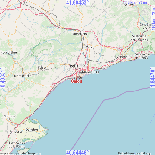
Salou GPS coordinates[2]
41° 4' 35.868" North, 1° 8' 29.868" East
| Map corner | latitude | longitude |
|---|---|---|
| Upper-left | 41.60453°, | 0.43851° |
| Center: | 41.07663°, | 1.14163° |
| Lower-right: | 40.54446°, | 1.84476° |
| Map W x H: | 117.9×117.9 km | = 73.3×73.3mi |
| max Lat: | 43.74134° ⇑49.6% North |
| Salou: | 41.07663° |
| min Lat: | ⇓50.4% South 27.64134° |
| min Long | Salou | max Long |
| -18.00367° | 1.14163° | 4.2899° |
| W 90.9%⇐ | ⇒9.1% E |
Elevation
Elevation of Salou is 6 m = 20 ft, and this is 592 m = 1942 ft below average elevation for this country.
| Max E: |
1682 m = 5518 ft | 99.5% |
| Avg. | 598 m = 1962 ft | |
| Salou | 6 m = 20 ft | |
Min E: |
0 m = 0 ft | 0.5% |
See also: Spain elevation on elevation.city.
Geographical zone
Salou is located in North temperate zone (between Tropic of Cancer and the Arctic Circle). Distance of this Northern Tropic circle is 1961.4 km =1218.8 mi to South.| Distance of | km | miles | from Salou |
|---|---|---|---|
| North Pole | 5439.8 | 3380.1 | to North |
| Arctic Circle | 2833.9 | 1760.9 | to North |
| Tropic Cancer | 1961.4 | 1218.8 | to South |
| Equator | 4567.3 | 2838 | to South |


Nearby cities:
15 places around Salou: (largest is in red/bold)
• Almoster
13.7 km =8.5 mi,  349°
349°
• Botarell
14.4 km =8.9 mi,  297°
297°
• Cambrils
6.9 km =4.3 mi,  263°
263°
• Constantí
10.5 km =6.5 mi,  34°
34°
• La Canonja
5.9 km =3.7 mi, 33°
• La Pineda
3.6 km =2.2 mi,  90°
90°
• Maspujols
14.2 km =8.8 mi,  325°
325°
• Mont-roig del Camp
15.3 km =9.5 mi,  274°
274°
• Reus
9.3 km =5.8 mi,  341°
341°
• Riudoms
9.9 km =6.2 mi,  309°
309°
• Tarragona
10.1 km =6.3 mi,  63°
63°
• Vila-seca
3.9 km =2.4 mi,  7°
7°
• els Pallaresos
15.4 km =9.6 mi,  44°
44°
• la Pobla de Mafumet
13.4 km =8.3 mi, 27°
• les Borges del Camp
14.5 km =9 mi, 313°
Sources, notices
• [Note1] Compared only with cities in Spain existing in our database
• [Src1] Map data: © OpenStreetMap contributors (CC-BY-SA)
• [Src2] Other city data from geonames.org with taken over terms of usage.
• [Src3] Geographical zone / Annual Mean Temperature by Robert A. Rohde @ Wikipedia
