Vila-seca geodata
Vila-seca (Catalonia) is a populated place; located in Spain in Europe/Madrid (GMT+2) time zone. With population of 20,866 people, there are 458 cities with bigger population in this country. Compared to other cities in Spain, 51.2% of cities are located further ↓South; 90.9% of cities are located further ←West and 92.7% of cities have higher elevation than Vila-seca. Note1


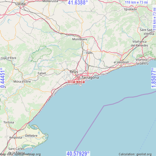
Vila-seca GPS coordinates[2]
41° 6' 40.248" North, 1° 8' 51.504" East
| Map corner | latitude | longitude |
|---|---|---|
| Upper-left | 41.6388°, | 0.44451° |
| Center: | 41.11118°, | 1.14764° |
| Lower-right: | 40.57929°, | 1.85077° |
| Map W x H: | 117.8×117.8 km | = 73.2×73.2mi |
| max Lat: | 43.74134° ⇑48.8% North |
| Vila-seca: | 41.11118° |
| min Lat: | ⇓51.2% South 27.64134° |
| min Long | Vila-seca | max Long |
| -18.00367° | 1.14764° | 4.2899° |
| W 90.9%⇐ | ⇒9.1% E |
Elevation
Elevation of Vila-seca is 40 m = 131 ft, and this is 558 m = 1831 ft below average elevation for this country.
| Max E: |
1682 m = 5518 ft | 92.7% |
| Avg. | 598 m = 1962 ft | |
| Vila-seca | 40 m = 131 ft | |
Min E: |
0 m = 0 ft | 7.3% |
See also: Spain elevation on elevation.city.
Geographical zone
Vila-seca is located in North temperate zone (between Tropic of Cancer and the Arctic Circle). Distance of this Northern Tropic circle is 1965.2 km =1221.1 mi to South.| Distance of | km | miles | from Vila-seca |
|---|---|---|---|
| North Pole | 5435.9 | 3377.7 | to North |
| Arctic Circle | 2830 | 1758.5 | to North |
| Tropic Cancer | 1965.2 | 1221.1 | to South |
| Equator | 4571.1 | 2840.3 | to South |


Nearby cities:
15 places around Vila-seca: (largest is in red/bold)
• Almoster
10.1 km =6.3 mi,  342°
342°
• Cambrils
8.7 km =5.4 mi,  238°
238°
• Constantí
7.2 km =4.5 mi,  48°
48°
• La Canonja
3 km =1.9 mi,  68°
68°
• La Pineda
5 km =3.1 mi,  141°
141°
• La Selva del Camp
11.5 km =7.1 mi,  356°
356°
• Maspujols
11.7 km =7.3 mi,  312°
312°
• Perafort
12.7 km =7.9 mi, 45°
• Reus
6.1 km =3.8 mi,  325°
325°
• Riudoms
8.5 km =5.3 mi,  286°
286°
• Salou
3.9 km =2.4 mi,  187°
187°
• Tarragona
8.6 km =5.3 mi,  85°
85°
• els Pallaresos
12.5 km =7.8 mi,  55°
55°
• la Pobla de Mafumet
9.9 km =6.2 mi,  35°
35°
• les Borges del Camp
12.6 km =7.8 mi,  299°
299°
Sources, notices
• [Note1] Compared only with cities in Spain existing in our database
• [Src1] Map data: © OpenStreetMap contributors (CC-BY-SA)
• [Src2] Other city data from geonames.org with taken over terms of usage.
• [Src3] Geographical zone / Annual Mean Temperature by Robert A. Rohde @ Wikipedia
