Maspujols geodata
Maspujols (Catalonia) is a populated place; located in Spain in Europe/Madrid (GMT+2) time zone. With population of 527 people, there are 3799 cities with bigger population in this country. Compared to other cities in Spain, 52.7% of cities are located further ↓South; 90.6% of cities are located further ←West and 80% of cities have higher elevation than Maspujols. Note1


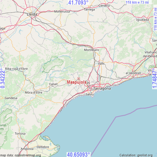
Maspujols GPS coordinates[2]
41° 10' 56.1" North, 1° 2' 43.224" East
| Map corner | latitude | longitude |
|---|---|---|
| Upper-left | 41.7093°, | 0.34222° |
| Center: | 41.18225°, | 1.04534° |
| Lower-right: | 40.65093°, | 1.74847° |
| Map W x H: | 117.7×117.7 km | = 73.1×73.1mi |
| max Lat: | 43.74134° ⇑47.3% North |
| Maspujols: | 41.18225° |
| min Lat: | ⇓52.7% South 27.64134° |
| min Long | Maspujols | max Long |
| -18.00367° | 1.04534° | 4.2899° |
| W 90.6%⇐ | ⇒9.4% E |
Elevation
Elevation of Maspujols is 219 m = 719 ft, and this is 379 m = 1243 ft below average elevation for this country.
| Max E: |
1682 m = 5518 ft | 80% |
| Avg. | 598 m = 1962 ft | |
| Maspujols | 219 m = 719 ft | |
Min E: |
0 m = 0 ft | 20% |
See also: Spain elevation on elevation.city.
Geographical zone
Maspujols is located in North temperate zone (between Tropic of Cancer and the Arctic Circle). Distance of this Northern Tropic circle is 1973.1 km =1226 mi to South.| Distance of | km | miles | from Maspujols |
|---|---|---|---|
| North Pole | 5428 | 3372.8 | to North |
| Arctic Circle | 2822.1 | 1753.6 | to North |
| Tropic Cancer | 1973.1 | 1226 | to South |
| Equator | 4579 | 2845.3 | to South |


Nearby cities:
15 places around Maspujols: (largest is in red/bold)
• Alforja
6.7 km =4.2 mi,  298°
298°
• Almoster
5.8 km =3.6 mi,  72°
72°
• Botarell
6.9 km =4.3 mi,  222°
222°
• Cambrils
12.5 km =7.8 mi,  174°
174°
• Duesaigües
10 km =6.2 mi,  249°
249°
• La Selva del Camp
8.6 km =5.3 mi, 65°
• Mont-ral
12.1 km =7.5 mi,  22°
22°
• Reus
5.9 km =3.7 mi,  119°
119°
• Riudecanyes
8.5 km =5.3 mi,  230°
230°
• Riudecols
6 km =3.7 mi,  255°
255°
• Riudoms
5.5 km =3.4 mi,  175°
175°
• Vila-seca
11.7 km =7.3 mi,  132°
132°
• Vilanova d'Escornalbou
11.9 km =7.4 mi, 232°
• Vilaplana
5.2 km =3.2 mi,  348°
348°
• les Borges del Camp
3 km =1.9 mi, 234°
Sources, notices
• [Note1] Compared only with cities in Spain existing in our database
• [Src1] Map data: © OpenStreetMap contributors (CC-BY-SA)
• [Src2] Other city data from geonames.org with taken over terms of usage.
• [Src3] Geographical zone / Annual Mean Temperature by Robert A. Rohde @ Wikipedia
