Almoster geodata
Almoster (Catalonia) is a populated place; located in Spain in Europe/Madrid (GMT+2) time zone. With population of 1,086 people, there are 2837 cities with bigger population in this country. Compared to other cities in Spain, 53.1% of cities are located further ↓South; 90.8% of cities are located further ←West and 76.2% of cities have higher elevation than Almoster. Note1
Administrative division(s):
- Level 1: Catalonia
- Level 2: Província de Tarragona
- Level 3: la Selva del Camp


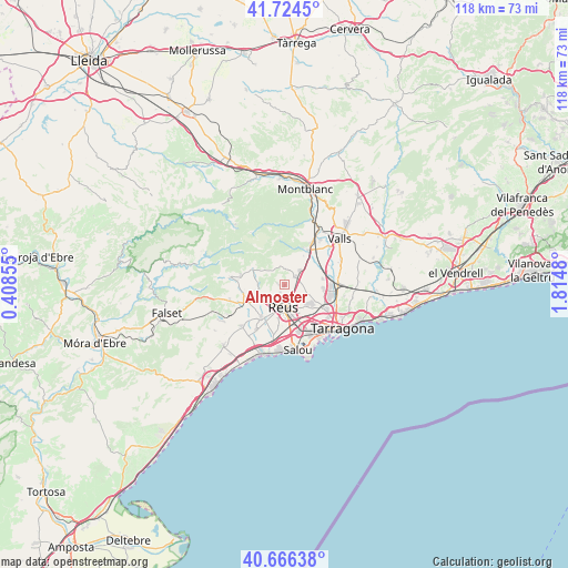
Almoster GPS coordinates[2]
41° 11' 51.288" North, 1° 6' 42.012" East
| Map corner | latitude | longitude |
|---|---|---|
| Upper-left | 41.7245°, | 0.40855° |
| Center: | 41.19758°, | 1.11167° |
| Lower-right: | 40.66638°, | 1.8148° |
| Map W x H: | 117.7×117.7 km | = 73.1×73.1mi |
| max Lat: | 43.74134° ⇑46.9% North |
| Almoster: | 41.19758° |
| min Lat: | ⇓53.1% South 27.64134° |
| min Long | Almoster | max Long |
| -18.00367° | 1.11167° | 4.2899° |
| W 90.8%⇐ | ⇒9.2% E |
Elevation
Elevation of Almoster is 282 m = 925 ft, and this is 316 m = 1037 ft below average elevation for this country.
| Max E: |
1682 m = 5518 ft | 76.2% |
| Avg. | 598 m = 1962 ft | |
| Almoster | 282 m = 925 ft | |
Min E: |
0 m = 0 ft | 23.8% |
See also: Spain elevation on elevation.city.
Geographical zone
Almoster is located in North temperate zone (between Tropic of Cancer and the Arctic Circle). Distance of this Northern Tropic circle is 1974.8 km =1227.1 mi to South.| Distance of | km | miles | from Almoster |
|---|---|---|---|
| North Pole | 5426.3 | 3371.7 | to North |
| Arctic Circle | 2820.4 | 1752.5 | to North |
| Tropic Cancer | 1974.8 | 1227.1 | to South |
| Equator | 4580.7 | 2846.3 | to South |


Nearby cities:
15 places around Almoster: (largest is in red/bold)
• Alcover
8.7 km =5.4 mi,  34°
34°
• Alforja
11.5 km =7.1 mi,  277°
277°
• Constantí
9.7 km =6 mi,  119°
119°
• La Canonja
10.3 km =6.4 mi,  145°
145°
• La Selva del Camp
3 km =1.9 mi,  49°
49°
• Maspujols
5.8 km =3.6 mi,  252°
252°
• Mont-ral
9.6 km =6 mi,  354°
354°
• Perafort
12.1 km =7.5 mi,  93°
93°
• Reus
4.6 km =2.9 mi,  184°
184°
• Riudecols
11.8 km =7.3 mi, 254°
• Riudoms
8.8 km =5.5 mi,  215°
215°
• Vila-seca
10.1 km =6.3 mi,  162°
162°
• Vilaplana
7.4 km =4.6 mi,  297°
297°
• la Pobla de Mafumet
8.9 km =5.5 mi,  100°
100°
• les Borges del Camp
8.7 km =5.4 mi, 246°
Sources, notices
• [Note1] Compared only with cities in Spain existing in our database
• [Src1] Map data: © OpenStreetMap contributors (CC-BY-SA)
• [Src2] Other city data from geonames.org with taken over terms of usage.
• [Src3] Geographical zone / Annual Mean Temperature by Robert A. Rohde @ Wikipedia
