Roses geodata
Roses (Catalonia) is a seat of a third-order administrative division; located in Spain in Europe/Madrid (GMT+2) time zone. With population of 20,197 people, there are 475 cities with bigger population in this country. Compared to other cities in Spain, 80.9% of cities are located further ↓South; 99.7% of cities are located further ←West and 98.2% of cities have higher elevation than Roses. Note1


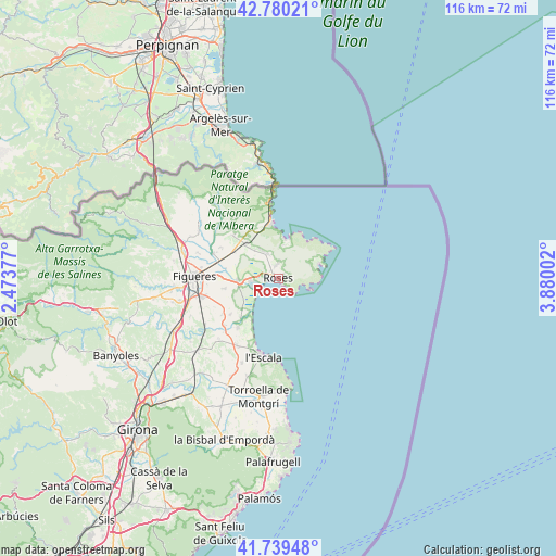
Roses GPS coordinates[2]
42° 15' 43.164" North, 3° 10' 36.804" East
| Map corner | latitude | longitude |
|---|---|---|
| Upper-left | 42.78021°, | 2.47377° |
| Center: | 42.26199°, | 3.17689° |
| Lower-right: | 41.73948°, | 3.88002° |
| Map W x H: | 115.7×115.7 km | = 71.9×71.9mi |
| max Lat: | 43.74134° ⇑19.1% North |
| Roses: | 42.26199° |
| min Lat: | ⇓80.9% South 27.64134° |
| min Long | Roses | max Long |
| -18.00367° | 3.17689° | 4.2899° |
| W 99.7%⇐ | ⇒0.3% E |
Elevation
Elevation of Roses is 11 m = 36 ft, and this is 587 m = 1926 ft below average elevation for this country.
| Max E: |
1682 m = 5518 ft | 98.2% |
| Avg. | 598 m = 1962 ft | |
| Roses | 11 m = 36 ft | |
Min E: |
0 m = 0 ft | 1.8% |
See also: Spain elevation on elevation.city.
Geographical zone
Roses is located in North temperate zone (between Tropic of Cancer and the Arctic Circle). Distance of this Northern Tropic circle is 2093.2 km =1300.7 mi to South.| Distance of | km | miles | from Roses |
|---|---|---|---|
| North Pole | 5308 | 3298.2 | to North |
| Arctic Circle | 2702.1 | 1679 | to North |
| Tropic Cancer | 2093.2 | 1300.7 | to South |
| Equator | 4699.1 | 2919.9 | to South |


Nearby cities:
15 places around Roses: (largest is in red/bold)
• Cadaqués
8.8 km =5.5 mi,  70°
70°
• Castelló d'Empúries
8.4 km =5.2 mi,  266°
266°
• Empuriabrava
4.9 km =3 mi,  250°
250°
• Fortià
11.6 km =7.2 mi,  259°
259°
• Garriguella
12.9 km =8 mi,  314°
314°
• Llançà
11.3 km =7 mi,  349°
349°
• Pau
7.8 km =4.8 mi,  320°
320°
• Peralada
14.7 km =9.1 mi,  290°
290°
• Riumors
11.8 km =7.3 mi, 250°
• Sant Pere Pescador
11.3 km =7 mi,  223°
223°
• Vila-sacra
13 km =8.1 mi, 271°
• Vilajuïga
9.9 km =6.2 mi, 315°
• Vilamacolum
12.3 km =7.6 mi,  233°
233°
• el Port de la Selva
8.6 km =5.3 mi,  15°
15°
• l'Armentera
13.1 km =8.1 mi, 220°
Sources, notices
• [Note1] Compared only with cities in Spain existing in our database
• [Src1] Map data: © OpenStreetMap contributors (CC-BY-SA)
• [Src2] Other city data from geonames.org with taken over terms of usage.
• [Src3] Geographical zone / Annual Mean Temperature by Robert A. Rohde @ Wikipedia
