Anento geodata
Anento (Aragon) is a seat of a third-order administrative division; located in Spain in Europe/Madrid (GMT+2) time zone. With population of 200 people, there are 5036 cities with bigger population in this country. Compared to other cities in Spain, 50.2% of cities are located further ↓South; 74.4% of cities are located further ←West and 81.6% of cities have lower elevation than Anento. Note1


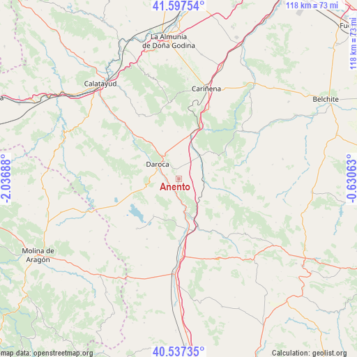
Anento GPS coordinates[2]
41° 4' 10.488" North, 1° 20' 1.5" West
| Map corner | latitude | longitude |
|---|---|---|
| Upper-left | 41.59754°, | -2.03688° |
| Center: | 41.06958°, | -1.33375° |
| Lower-right: | 40.53735°, | -0.63063° |
| Map W x H: | 117.9×117.9 km | = 73.3×73.3mi |
| max Lat: | 43.74134° ⇑49.8% North |
| Anento: | 41.06958° |
| min Lat: | ⇓50.2% South 27.64134° |
| min Long | Anento | max Long |
| -18.00367° | -1.33375° | 4.2899° |
| W 74.4%⇐ | ⇒25.6% E |
Elevation
Elevation of Anento is 913 m = 2995 ft, and this is 315 m = 1033 ft above average elevation for this country.
| Max E: |
1682 m = 5518 ft | 18.4% |
| Anento | 913 m 2995 ft | |
| Avg. | 598 m = 1962 ft | |
Min E: |
0 m = 0 ft | 81.6% |
See also: Spain elevation on elevation.city.
Geographical zone
Anento is located in North temperate zone (between Tropic of Cancer and the Arctic Circle). Distance of this Northern Tropic circle is 1960.6 km =1218.3 mi to South.| Distance of | km | miles | from Anento |
|---|---|---|---|
| North Pole | 5440.6 | 3380.6 | to North |
| Arctic Circle | 2834.7 | 1761.4 | to North |
| Tropic Cancer | 1960.6 | 1218.3 | to South |
| Equator | 4566.5 | 2837.5 | to South |


Nearby cities:
15 places around Anento: (largest is in red/bold)
• Burbáguena
5.8 km =3.6 mi,  183°
183°
• Báguena
3.7 km =2.3 mi,  213°
213°
• Cucalón
10.1 km =6.3 mi,  79°
79°
• Daroca
8.5 km =5.3 mi,  306°
306°
• Ferreruela de Huerva
8.4 km =5.2 mi,  94°
94°
• Lechón
4.5 km =2.8 mi,  65°
65°
• Nombrevilla
4.7 km =2.9 mi,  333°
333°
• Retascón
9.2 km =5.7 mi, 332°
• Romanos
8 km =5 mi,  37°
37°
• San Martín del Río
4.5 km =2.8 mi,  265°
265°
• Val de San Martín
9.8 km =6.1 mi,  262°
262°
• Valdehorna
7.6 km =4.7 mi, 272°
• Villahermosa del Campo
8.5 km =5.3 mi,  58°
58°
• Villanueva de Jiloca
4.7 km =2.9 mi,  279°
279°
• Villarroya del Campo
8.2 km =5.1 mi,  5°
5°
Sources, notices
• [Note1] Compared only with cities in Spain existing in our database
• [Src1] Map data: © OpenStreetMap contributors (CC-BY-SA)
• [Src2] Other city data from geonames.org with taken over terms of usage.
• [Src3] Geographical zone / Annual Mean Temperature by Robert A. Rohde @ Wikipedia
