Herce geodata
Herce (La Rioja) is a seat of a third-order administrative division; located in Spain in Europe/Madrid (GMT+2) time zone. With population of 356 people, there are 4293 cities with bigger population in this country. Compared to other cities in Spain, 79.6% of cities are located further ↓South; 65.2% of cities are located further ←West and 55.5% of cities have higher elevation than Herce. Note1


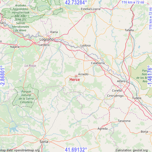
Herce GPS coordinates[2]
42° 12' 51.228" North, 2° 9' 53.568" West
| Map corner | latitude | longitude |
|---|---|---|
| Upper-left | 42.73284°, | -2.86801° |
| Center: | 42.21423°, | -2.16488° |
| Lower-right: | 41.69132°, | -1.46176° |
| Map W x H: | 115.8×115.8 km | = 72×72mi |
| max Lat: | 43.74134° ⇑20.4% North |
| Herce: | 42.21423° |
| min Lat: | ⇓79.6% South 27.64134° |
| min Long | Herce | max Long |
| -18.00367° | -2.16488° | 4.2899° |
| W 65.2%⇐ | ⇒34.8% E |
Elevation
Elevation of Herce is 589 m = 1932 ft, and this is 9 m = 30 ft below average elevation for this country.
| Max E: |
1682 m = 5518 ft | 55.5% |
| Avg. | 598 m = 1962 ft | |
| Herce | 589 m = 1932 ft | |
Min E: |
0 m = 0 ft | 44.5% |
See also: Spain elevation on elevation.city.
Geographical zone
Herce is located in North temperate zone (between Tropic of Cancer and the Arctic Circle). Distance of this Northern Tropic circle is 2087.9 km =1297.4 mi to South.| Distance of | km | miles | from Herce |
|---|---|---|---|
| North Pole | 5313.3 | 3301.5 | to North |
| Arctic Circle | 2707.4 | 1682.3 | to North |
| Tropic Cancer | 2087.9 | 1297.4 | to South |
| Equator | 4693.8 | 2916.6 | to South |


Nearby cities:
15 places around Herce: (largest is in red/bold)
• Arnedillo
5.9 km =3.7 mi,  267°
267°
• Arnedo
5.5 km =3.4 mi,  73°
73°
• Autol
13.1 km =8.1 mi,  88°
88°
• Bergasa
5.1 km =3.2 mi,  32°
32°
• Bergasillas Bajera
3.4 km =2.1 mi,  9°
9°
• Enciso
11.2 km =7 mi,  230°
230°
• Munilla
11.1 km =6.9 mi,  255°
255°
• Muro de Aguas
10 km =6.2 mi,  153°
153°
• Ocón
11.3 km =7 mi,  326°
326°
• Préjano
3.3 km =2.1 mi,  201°
201°
• Quel
9.5 km =5.9 mi,  79°
79°
• Robres del Castillo
12.5 km =7.8 mi,  303°
303°
• Santa Eulalia Bajera
2.3 km =1.4 mi, 256°
• Tudelilla
10.3 km =6.4 mi,  22°
22°
• Villarroya
12.2 km =7.6 mi,  139°
139°
Sources, notices
• [Note1] Compared only with cities in Spain existing in our database
• [Src1] Map data: © OpenStreetMap contributors (CC-BY-SA)
• [Src2] Other city data from geonames.org with taken over terms of usage.
• [Src3] Geographical zone / Annual Mean Temperature by Robert A. Rohde @ Wikipedia
