Munilla geodata
Munilla (La Rioja) is a seat of a third-order administrative division; located in Spain in Europe/Madrid (GMT+2) time zone. With population of 124 people, there are 5647 cities with bigger population in this country. Compared to other cities in Spain, 79% of cities are located further ↓South; 63.5% of cities are located further ←West and 68.6% of cities have lower elevation than Munilla. Note1


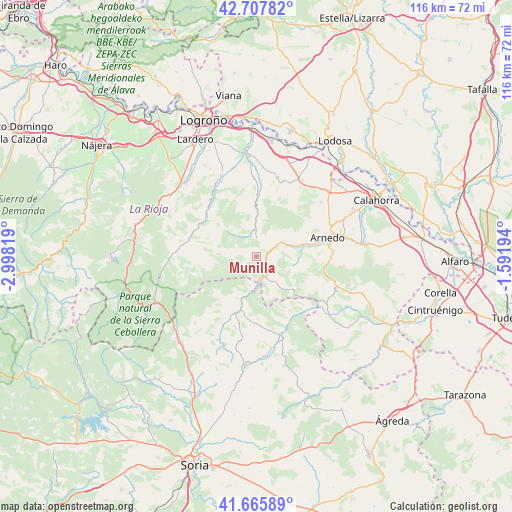
Munilla GPS coordinates[2]
42° 11' 20.4" North, 2° 17' 42.216" West
| Map corner | latitude | longitude |
|---|---|---|
| Upper-left | 42.70782°, | -2.99819° |
| Center: | 42.189°, | -2.29506° |
| Lower-right: | 41.66589°, | -1.59194° |
| Map W x H: | 115.9×115.9 km | = 72×72mi |
| max Lat: | 43.74134° ⇑21% North |
| Munilla: | 42.189° |
| min Lat: | ⇓79% South 27.64134° |
| min Long | Munilla | max Long |
| -18.00367° | -2.29506° | 4.2899° |
| W 63.5%⇐ | ⇒36.5% E |
Elevation
Elevation of Munilla is 803 m = 2635 ft, and this is 205 m = 673 ft above average elevation for this country.
| Max E: |
1682 m = 5518 ft | 31.4% |
| Munilla | 803 m 2635 ft | |
| Avg. | 598 m = 1962 ft | |
Min E: |
0 m = 0 ft | 68.6% |
See also: Spain elevation on elevation.city.
Geographical zone
Munilla is located in North temperate zone (between Tropic of Cancer and the Arctic Circle). Distance of this Northern Tropic circle is 2085.1 km =1295.6 mi to South.| Distance of | km | miles | from Munilla |
|---|---|---|---|
| North Pole | 5316.1 | 3303.3 | to North |
| Arctic Circle | 2710.2 | 1684 | to North |
| Tropic Cancer | 2085.1 | 1295.6 | to South |
| Equator | 4691 | 2914.9 | to South |


Nearby cities:
15 places around Munilla: (largest is in red/bold)
• Arnedillo
5.5 km =3.4 mi,  62°
62°
• Bergasa
15.2 km =9.4 mi, 62°
• Bergasillas Bajera
12.8 km =8 mi, 61°
• Enciso
4.9 km =3 mi,  154°
154°
• Herce
11.1 km =6.9 mi,  75°
75°
• Hornillos de Cameros
10.5 km =6.5 mi,  282°
282°
• Ocón
13 km =8.1 mi,  20°
20°
• Préjano
9.5 km =5.9 mi,  91°
91°
• Robres del Castillo
9.7 km =6 mi,  1°
1°
• Santa Eulalia Bajera
8.8 km =5.5 mi,  74°
74°
• Soto en Cameros
15.2 km =9.4 mi,  314°
314°
• Terroba
14.5 km =9 mi,  302°
302°
• Villar del Río
13.4 km =8.3 mi,  200°
200°
• Yanguas
10.4 km =6.5 mi, 200°
• Zarzosa
4 km =2.5 mi,  260°
260°
Sources, notices
• [Note1] Compared only with cities in Spain existing in our database
• [Src1] Map data: © OpenStreetMap contributors (CC-BY-SA)
• [Src2] Other city data from geonames.org with taken over terms of usage.
• [Src3] Geographical zone / Annual Mean Temperature by Robert A. Rohde @ Wikipedia
