Robregordo geodata
Robregordo (Madrid) is a seat of a third-order administrative division; located in Spain in Europe/Madrid (GMT+2) time zone. In our database, there are 6762 cities with bigger population. Compared to other cities in Spain, 51.1% of cities are located further ↓South; 53.6% of cities are located further →East and 98.6% of cities have lower elevation than Robregordo. Note1


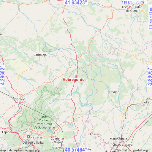
Robregordo GPS coordinates[2]
41° 6' 23.652" North, 3° 35' 37.284" West
| Map corner | latitude | longitude |
|---|---|---|
| Upper-left | 41.63423°, | -4.29682° |
| Center: | 41.10657°, | -3.59369° |
| Lower-right: | 40.57464°, | -2.89057° |
| Map W x H: | 117.8×117.8 km | = 73.2×73.2mi |
| max Lat: | 43.74134° ⇑48.9% North |
| Robregordo: | 41.10657° |
| min Lat: | ⇓51.1% South 27.64134° |
| min Long | Robregordo | max Long |
| -18.00367° | -3.59369° | 4.2899° |
| W 46.4%⇐ | ⇒53.6% E |
Elevation
Elevation of Robregordo is 1300 m = 4265 ft, and this is 702 m = 2303 ft above average elevation for this country.
| Max E: |
1682 m = 5518 ft | 1.4% |
| Robregordo | 1300 m 4265 ft | |
| Avg. | 598 m = 1962 ft | |
Min E: |
0 m = 0 ft | 98.6% |
See also: Spain elevation on elevation.city.
Geographical zone
Robregordo is located in North temperate zone (between Tropic of Cancer and the Arctic Circle). Distance of this Northern Tropic circle is 1964.7 km =1220.8 mi to South.| Distance of | km | miles | from Robregordo |
|---|---|---|---|
| North Pole | 5436.4 | 3378 | to North |
| Arctic Circle | 2830.6 | 1758.9 | to North |
| Tropic Cancer | 1964.7 | 1220.8 | to South |
| Equator | 4570.6 | 2840 | to South |


Nearby cities:
15 places around Robregordo: (largest is in red/bold)
• Arcones
11 km =6.8 mi,  276°
276°
• Braojos
8.5 km =5.3 mi,  209°
209°
• Buitrago del Lozoya
13.3 km =8.3 mi,  194°
194°
• Casla
8.4 km =5.2 mi,  321°
321°
• Cerezo de Abajo
12.4 km =7.7 mi,  0°
0°
• Gascones
10.6 km =6.6 mi,  202°
202°
• Horcajo de la Sierra
4.4 km =2.7 mi,  170°
170°
• Horcajuelo de la Sierra
6.5 km =4 mi,  142°
142°
• Matabuena
13.8 km =8.6 mi,  265°
265°
• Montejo de la Sierra
7.5 km =4.7 mi,  134°
134°
• Prádena
8.7 km =5.4 mi,  294°
294°
• Prádena del Rincón
8.2 km =5.1 mi,  147°
147°
• Santa Marta del Cerro
14.6 km =9.1 mi,  328°
328°
• Somosierra
3.1 km =1.9 mi,  18°
18°
• Villavieja del Lozoya
13 km =8.1 mi, 208°
Sources, notices
• [Note1] Compared only with cities in Spain existing in our database
• [Src1] Map data: © OpenStreetMap contributors (CC-BY-SA)
• [Src2] Other city data from geonames.org with taken over terms of usage.
• [Src3] Geographical zone / Annual Mean Temperature by Robert A. Rohde @ Wikipedia
