Gascones geodata
Gascones (Madrid) is a seat of a third-order administrative division; located in Spain in Europe/Madrid (GMT+2) time zone. With population of 178 people, there are 5195 cities with bigger population in this country. Compared to other cities in Spain, 51.1% of cities are located further ↑North; 54.4% of cities are located further →East and 91.1% of cities have lower elevation than Gascones. Note1


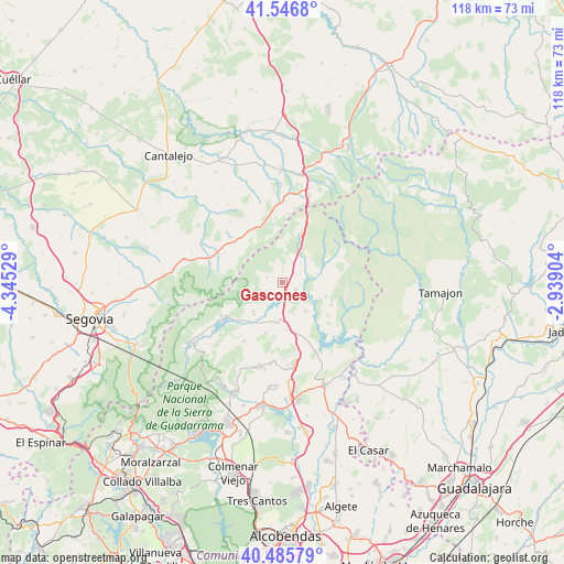
Gascones GPS coordinates[2]
41° 1' 6.348" North, 3° 38' 31.812" West
| Map corner | latitude | longitude |
|---|---|---|
| Upper-left | 41.5468°, | -4.34529° |
| Center: | 41.01843°, | -3.64217° |
| Lower-right: | 40.48579°, | -2.93904° |
| Map W x H: | 118×118 km | = 73.3×73.3mi |
| max Lat: | 43.74134° ⇑51.1% North |
| Gascones: | 41.01843° |
| min Lat: | ⇓48.9% South 27.64134° |
| min Long | Gascones | max Long |
| -18.00367° | -3.64217° | 4.2899° |
| W 45.6%⇐ | ⇒54.4% E |
Elevation
Elevation of Gascones is 1049 m = 3442 ft, and this is 451 m = 1480 ft above average elevation for this country.
| Max E: |
1682 m = 5518 ft | 8.9% |
| Gascones | 1049 m 3442 ft | |
| Avg. | 598 m = 1962 ft | |
Min E: |
0 m = 0 ft | 91.1% |
See also: Spain elevation on elevation.city.
Geographical zone
Gascones is located in North temperate zone (between Tropic of Cancer and the Arctic Circle). Distance of this Northern Tropic circle is 1954.9 km =1214.7 mi to South.| Distance of | km | miles | from Gascones |
|---|---|---|---|
| North Pole | 5446.2 | 3384.1 | to North |
| Arctic Circle | 2840.4 | 1764.9 | to North |
| Tropic Cancer | 1954.9 | 1214.7 | to South |
| Equator | 4560.8 | 2833.9 | to South |


Nearby cities:
15 places around Gascones: (largest is in red/bold)
• Arcones
13 km =8.1 mi,  328°
328°
• Berzosa del Lozoya
11.4 km =7.1 mi,  116°
116°
• Braojos
2.4 km =1.5 mi,  357°
357°
• Buitrago del Lozoya
3.1 km =1.9 mi,  166°
166°
• Gallegos
13.6 km =8.5 mi,  297°
297°
• Garganta de los Montes
11.5 km =7.1 mi,  197°
197°
• Horcajo de la Sierra
7.2 km =4.5 mi,  41°
41°
• Horcajuelo de la Sierra
9.3 km =5.8 mi,  59°
59°
• Matabuena
13 km =8.1 mi,  311°
311°
• Montejo de la Sierra
10.5 km =6.5 mi, 64°
• Prádena del Rincón
9 km =5.6 mi,  71°
71°
• Robledillo de la Jara
12.6 km =7.8 mi,  126°
126°
• Robregordo
10.6 km =6.6 mi,  22°
22°
• Somosierra
13.7 km =8.5 mi, 21°
• Villavieja del Lozoya
2.7 km =1.7 mi,  234°
234°
Sources, notices
• [Note1] Compared only with cities in Spain existing in our database
• [Src1] Map data: © OpenStreetMap contributors (CC-BY-SA)
• [Src2] Other city data from geonames.org with taken over terms of usage.
• [Src3] Geographical zone / Annual Mean Temperature by Robert A. Rohde @ Wikipedia
