Braojos geodata
Braojos (Madrid) is a seat of a third-order administrative division; located in Spain in Europe/Madrid (GMT+2) time zone. With population of 193 people, there are 5085 cities with bigger population in this country. Compared to other cities in Spain, 50.6% of cities are located further ↑North; 54.5% of cities are located further →East and 96.5% of cities have lower elevation than Braojos. Note1


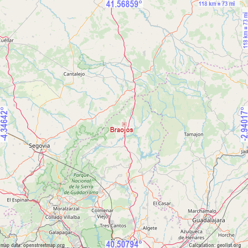
Braojos GPS coordinates[2]
41° 2' 25.44" North, 3° 38' 35.844" West
| Map corner | latitude | longitude |
|---|---|---|
| Upper-left | 41.56859°, | -4.34642° |
| Center: | 41.0404°, | -3.64329° |
| Lower-right: | 40.50794°, | -2.94017° |
| Map W x H: | 117.9×117.9 km | = 73.3×73.3mi |
| max Lat: | 43.74134° ⇑50.6% North |
| Braojos: | 41.0404° |
| min Lat: | ⇓49.4% South 27.64134° |
| min Long | Braojos | max Long |
| -18.00367° | -3.64329° | 4.2899° |
| W 45.5%⇐ | ⇒54.5% E |
Elevation
Elevation of Braojos is 1189 m = 3901 ft, and this is 591 m = 1939 ft above average elevation for this country.
| Max E: |
1682 m = 5518 ft | 3.5% |
| Braojos | 1189 m 3901 ft | |
| Avg. | 598 m = 1962 ft | |
Min E: |
0 m = 0 ft | 96.5% |
See also: Spain elevation on elevation.city.
Geographical zone
Braojos is located in North temperate zone (between Tropic of Cancer and the Arctic Circle). Distance of this Northern Tropic circle is 1957.3 km =1216.2 mi to South.| Distance of | km | miles | from Braojos |
|---|---|---|---|
| North Pole | 5443.8 | 3382.6 | to North |
| Arctic Circle | 2837.9 | 1763.4 | to North |
| Tropic Cancer | 1957.3 | 1216.2 | to South |
| Equator | 4563.3 | 2835.5 | to South |


Nearby cities:
15 places around Braojos: (largest is in red/bold)
• Arcones
11 km =6.8 mi,  322°
322°
• Berzosa del Lozoya
12.8 km =8 mi,  125°
125°
• Buitrago del Lozoya
5.6 km =3.5 mi,  171°
171°
• Gallegos
12.6 km =7.8 mi,  287°
287°
• Garganta de los Montes
13.8 km =8.6 mi,  194°
194°
• Gascones
2.4 km =1.5 mi,  177°
177°
• Horcajo de la Sierra
5.7 km =3.5 mi,  58°
58°
• Horcajuelo de la Sierra
8.4 km =5.2 mi,  74°
74°
• Matabuena
11.4 km =7.1 mi,  302°
302°
• Montejo de la Sierra
9.7 km =6 mi,  77°
77°
• Prádena
11.6 km =7.2 mi,  341°
341°
• Prádena del Rincón
8.6 km =5.3 mi,  87°
87°
• Robregordo
8.5 km =5.3 mi,  29°
29°
• Somosierra
11.5 km =7.1 mi, 26°
• Villavieja del Lozoya
4.6 km =2.9 mi,  207°
207°
Sources, notices
• [Note1] Compared only with cities in Spain existing in our database
• [Src1] Map data: © OpenStreetMap contributors (CC-BY-SA)
• [Src2] Other city data from geonames.org with taken over terms of usage.
• [Src3] Geographical zone / Annual Mean Temperature by Robert A. Rohde @ Wikipedia
