Robleda geodata
Robleda (Castille and León) is a seat of a third-order administrative division; located in Spain in Europe/Madrid (GMT+2) time zone. With population of 533 people, there are 3780 cities with bigger population in this country. Compared to other cities in Spain, 64.3% of cities are located further ↑North; 92% of cities are located further →East and 73.5% of cities have lower elevation than Robleda. Note1
Administrative division(s):
- Level 1: Castille and León
- Level 2: Provincia de Salamanca
- Level 3: Robleda


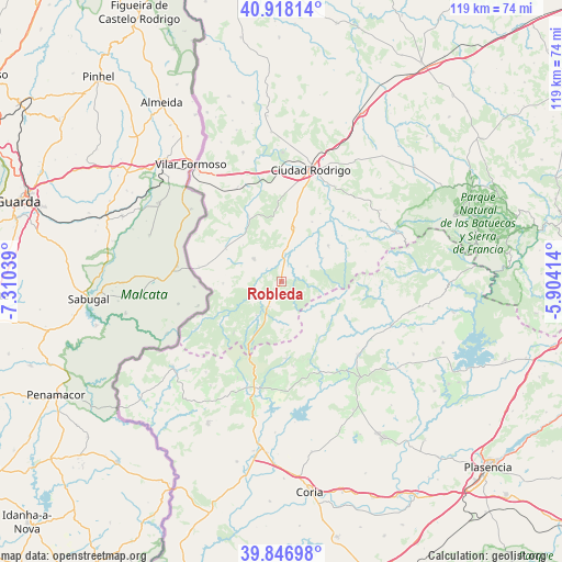
Robleda GPS coordinates[2]
40° 23' 4.884" North, 6° 36' 26.136" West
| Map corner | latitude | longitude |
|---|---|---|
| Upper-left | 40.91814°, | -7.31039° |
| Center: | 40.38469°, | -6.60726° |
| Lower-right: | 39.84698°, | -5.90414° |
| Map W x H: | 119.1×119.1 km | = 74×74mi |
| max Lat: | 43.74134° ⇑64.3% North |
| Robleda: | 40.38469° |
| min Lat: | ⇓35.7% South 27.64134° |
| min Long | Robleda | max Long |
| -18.00367° | -6.60726° | 4.2899° |
| W 8%⇐ | ⇒92% E |
Elevation
Elevation of Robleda is 839 m = 2753 ft, and this is 241 m = 791 ft above average elevation for this country.
| Max E: |
1682 m = 5518 ft | 26.5% |
| Robleda | 839 m 2753 ft | |
| Avg. | 598 m = 1962 ft | |
Min E: |
0 m = 0 ft | 73.5% |
See also: Spain elevation on elevation.city.
Geographical zone
Robleda is located in North temperate zone (between Tropic of Cancer and the Arctic Circle). Distance of this Northern Tropic circle is 1884.4 km =1170.9 mi to South.| Distance of | km | miles | from Robleda |
|---|---|---|---|
| North Pole | 5516.7 | 3427.9 | to North |
| Arctic Circle | 2910.8 | 1808.7 | to North |
| Tropic Cancer | 1884.4 | 1170.9 | to South |
| Equator | 4490.4 | 2790.2 | to South |


Nearby cities:
15 places around Robleda: (largest is in red/bold)
• Agallas
15.7 km =9.8 mi,  63°
63°
• Cadalso
17.3 km =10.7 mi,  161°
161°
• Campillo de Azaba
15.4 km =9.6 mi,  334°
334°
• Casillas de Flores
12.6 km =7.8 mi,  268°
268°
• Descargamaría
13.6 km =8.5 mi,  131°
131°
• Fuenteguinaldo
7.6 km =4.7 mi,  310°
310°
• Gata
16.4 km =10.2 mi,  176°
176°
• Herguijuela de Ciudad Rodrigo
11 km =6.8 mi,  41°
41°
• Ituero de Azaba
13.3 km =8.3 mi, 327°
• Martiago
12.6 km =7.8 mi,  52°
52°
• Pastores
16.7 km =10.4 mi,  29°
29°
• Peñaparda
8.8 km =5.5 mi,  216°
216°
• Puebla de Azaba
13.7 km =8.5 mi,  300°
300°
• Robledillo de Gata
13.4 km =8.3 mi,  121°
121°
• Villasrubias
5.8 km =3.6 mi,  207°
207°
Sources, notices
• [Note1] Compared only with cities in Spain existing in our database
• [Src1] Map data: © OpenStreetMap contributors (CC-BY-SA)
• [Src2] Other city data from geonames.org with taken over terms of usage.
• [Src3] Geographical zone / Annual Mean Temperature by Robert A. Rohde @ Wikipedia
